Organ Pipe Cactus National Monument ("OPCNM") is a 517 square mile UNESCO Biosphere Reserve and the only place in the U.S. where the organ pipe cactus and senita cactus are found (they are found in more abundance south of the border in Sonora, Mexico). It is the most beautiful desert I've ever seen and one of my favorite places anywhere in the world. It abuts the Mexican State of Sonora.
The southern boundary is 62 miles from the coastal port of Puerto Penasco and the northern boundary is 128 miles from Tucson, 128 miles from Phoenix and 173 miles from Yuma. The nearest town of any size on the U.S. side is 15 miles from the northern boundary in Ajo, which had a population of 3,705 in the 2000 census. On the Mexico side, Sonoyta is just 2.4 miles from the southern boundary and had a population of 12,849 in the 2010 census.
It is one of the most isolated, wild places in the lower 48 states. Its east boundary and half of its north boundary is adjacent to the Cabeza Prieta National Wildlife Refuge, which is 1,344 square miles, 90% of which is wilderness area. Surrounding Cabeza Prieta, creating further buffer for OPCNM, is the Barry M. Goldwater Air Force Range, which is 2,969 square miles. To the east of OPCNM is the Tohono O'Odham Indian Reservation which is 4,340 square miles and only had a population of 8,576 people in the 2000 census. South of the border, in Mexico, it connects to El Pinacate y Gran Desierto de Altar Biosphere Reserve which is 2,759 square miles. That is lots of mostly empty space.
I'm guessing that I've been there about 15 times and I've seen some amazing things, but have only seen a fraction of what it offers.
Ajo Range:
The Ajo Range is a portion of the east end of OPCNM. It is what is often termed a "desert island" or "
sky island," where species rich isolated mountains are surrounded by radically different lowlands. Mt. Ajo, the tallest mountain in the range, is 4,808 feet in elevation. The Ajo Range is one of the real treasures of OPCNM.
 |
The Ajo Range viewed from El Camino del Diablo, also known as Bates Well Road.
|
 |
| A smaller and more detailed portion of the Ajo Range |
Ajo Mountain Drive:
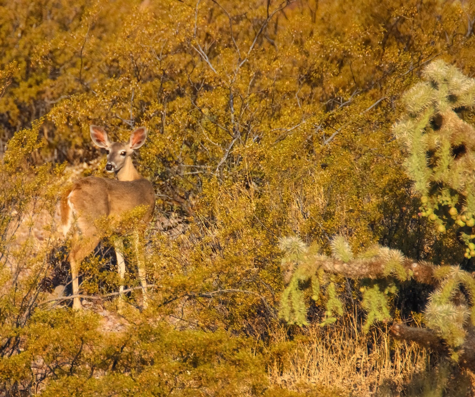
The Ajo Mountain Drive is a 21 mile loop over a mostly dirt road that begins just east of the Visitor's Center (across AZ 85). It is a two-way road for 1.9 miles through the Sonoyta Valley, then forks and becomes one-way, staying left and continuing on northeast through the Sonoyta Valley, then up through Diablo Canyon, a gap in the Diablo Mountains. Much of the road through this section is paved as it is steep in sections and is crossed by small arroyos that occasionally have running water that would wash out a dirt road. The road ascends northeast into the Ajo Mountain foothills to Arch Canyon, then turns south past Estes Canyon, then southwest around the end of the Diablo Mountains and back across the Sonoyta Valley where it hooks back into the two way road and the fork.
 |
| Coues or white-tailed deer, just past Diablo Canyon. |
 |
| This coyote disappears into the brush. I've seen quite a few coyotes, but this is the first one I've gotten any kind of photo of. |
My first visit to OPCNM was July 5, 1989. Our children were ages 8, 4 and 1. We were on a whirlwind visit of southern Arizona, including Chiricahua NM, Douglas, Bisbee, Tombstone, Fort Huachuca, and Tucson, which was 113 degrees, and I convinced Judy to stay the night of July 4th in Ajo, rather than to push on home, so that I could make a quick visit to OPCNM, a World Heritage Site, the next morning. I was desirous to spend as much time as I could there and Judy was determined to get home. My journal entry from that day reflects that tension:
"Shortly
before 8:00 we drove south to Organ Pipe Cactus National Monument. The visitor
center lies about 28 miles inside the monument. Judy was being patient with me
although not real happy with this delay in getting back home. Because Andrew [our one year old] was
asleep, she kept the car running while we went into the visitors center and got
a map, then we drove the 21 mile long Ajo Mountain loop, a dirt road. The
ranger said it would take two hours, but I really pushed it and did it in 40
minutes, over very bumpy and rocky roads. I wish we could have spent more time.
I think some of the scenery was the prettiest we’ve seen in Arizona,
particularly right up against the mountain, with the saguaro cactus and canyons
all arrayed. Unfortunately we couldn’t stop – Andrew would have awakened and
I’d have been dead meat. On the way out of the monument we ran over a
snake crossing the road, but couldn’t stop because Andrew would wake up."
I loved it so much I was determined to get back. The next year, 1990, we did a camping trip to OPCNM in April. Part of my journal entry for April 7, 1990 follows:
"We
drove to the visitor’s center at Organ Pipe and went through the exhibits,
reserved one of four spaces at the primitive campsite in Alamo Canyon, and then
went on the Ajo Mountain dirt road drive. We stopped beneath the arch at the
mouth of Arch Canyon and hiked around the first bend, teaching the kids various
kinds of cactus (cholla, prickly pear, hedgehog, saguaro, organ pipe),
ocotillo, etc. The plants and cactus were flowering, although it was a dry year
and not as spectacular as in previous wetter years. The pretty reds were out on
the ocotillo and some of the other yellow flowers. We ate a picnic on a bench
at the mouth of the canyon and talked with a couple visiting from England."
 |
| The arch above Arch Canyon. |
 |
| If you look closely, you can see that it is a double arch, a small arch sits on top of the big arch. |
 |
| Red marks the places I've hiked off the Ajo Mountain Road. |
In February 2017 I took the Ajo Mountain Drive with my son, Sam. It rained all the day before and rained on and off the day we took this drive. Boulder Canyon, a steep canyon between Arch Canyon and Estes Canyon, had a spectacular waterfall high up toward the top, something I'd not seen before. We parked the car and bushwhacked our way up into the canyon until we could not traverse it safely anymore. We did not reach the waterfall, but did get high enough to find running water coming down the canyon and got great views out across the Sonoyta Valley through gaps in the Diablo Mountains.
 |
| At the edge of Boulder Canyon looking west through the Diablo Mountains. |
From March 26 to 28, 2008, I visited OPCNM with some older scouts from our church scout troop. Several of us came early to reserve a camp site in Alamo Canyon and we decided to take the Ajo Mountain Drive and hike up through Estes Canyon to Bull Pasture.
 |
| Estes Canyon Wash is the line at the base of the hills in the center. |
 |
| Near the trailhead, looking up. |
 |
| An interesting section just above the wash with organ pipe cacti, ocotillo and fun rock formations. |
I'd asked a ranger at the visitor's center if there'd been any Gila monster sightings and she told me that a person had seen one in the wash in Estes Canyon. So rather than hiking the trail, I walked up the wash. I was rewarded when I heard a hissing sound off to my right and saw a beautiful
Gila monster up against some rocks, fulfilling a lifetime dream to see one.
 |
| Gila monster in Estes Canyon in 2008. |
 |
| Gila monster in Estes Canyon in 2017. |
We finished the hike up to Bull Pasture, but it was an after-thought after the Gila monster. Now, each time I visit OPCNM I try to take a walk through Estes Canyon with the hope that I'll see another one. That hope was rewarded in April 2017 when I saw another
Gila monster. I saw a German couple nearby when I spotted it and called them over to have a look. They had just seen a Gila monster in Arch Canyon a little earlier that morning, crossing the trail.
On the way out, heading east through the Sonoyta Valley, we got a good view of the sunset to the west.


Alamo Canyon Campground:

Alamo Canyon campground is 3 miles down a dirt road east off Hwy 85, leaving the highway at milepost 65.5, just north of a concrete bridge that crosses a wash. It is the jumping off point for my favorite area of OPCNM.
 |
| In 2017 I visited during a period of thunderstorms. This wash, just above Hwy 85 that I've never seen water in, was a river. |
There are four primitive campsites, open to tent camping only; there are no motor homes, trailers, generators or wood fires permitted.
 |
An area just north of the campground, then looking south.
|
 |
| Looking southwest - lots of saguaro cacti. |
 |
| North of the campground. |
 |
| Nights are spectacular in the campground. The Milky Way stands out as does the moon. |
 |
| I've also seen some wonderful sunsets from that location. |
In April 1990 we first camped there with our three young children. Our campsite was near saguaro and organ pipe cacti.
On a late-afternoon hike south of our campsite we walked toward where vultures were circling and scared a bunch of peccaries that jumped and grunted and made lots of noise. In April 1991 I was back with my scout troop.
 |
| Illegal aliens carry black plastic water bottles with them because they don't shine at night. It is quite common to come across them as you hike. |
In April 1998 I had my most fun experience there. I was with Sam and Andrew and we did an overnight backpacking trip, starting from the camp ground, then heading north to Grass Canyon where we pitched a tent and slept the night.
On our hike we encountered an amazingly nasty western diamondback rattlesnake that raised the upper half of its body off the ground like a cobra and rattled menacingly at us.
The next day we hiked up Grass Canyon, crossed over the spine of the Ajo Mountains, through a saddle, and followed a mostly dry wash back south to Alamo Canyon, making a loop.
 |
| The Grass Canyon Loop drawn onto a topo map. |
 |
| Grass Canyon is in the center of the photo. The low point in the range is the saddle you cross over. Alamo Canyon campground is out of the photo to the right. |
 |
| At the saddle, looking down into Grass Canyon. |
In the wash we watched a mellow western diamondback rattlesnake swim through a pool and completely ignore us, one of the most amazing things I've ever seen in the wild.
The hiking was tricky in places, with pools of standing water and maneuvering to avoid steep drops. I've seen the route we took referred to as the
Grass Canyon Loop.
In March 2008 I was back with the scouts again and we did the Grass Canyon Loop as a day hike. We encountered another western diamondback rattlesnake early on in the hike.
In May 2009, I camped in Alamo Canyon alone and got up in the middle of the night to see the organ pipe cactus flowers opened up. I saw a bat at one of the flowers licking the nectar.
 |
| Organ pipe cactus bloom at night. |
Earlier in the day I'd asked at the visitors center if there were horned lizards in the monument. The ranger told me she'd never heard of people seeing them. That evening I saw a baby regal horned lizard about 100 yards from my campsite.

South Puerto Blanco Drive to Quitobaquito Spring:
4.3 miles south of the visitors center, the dirt South Puerto Blanco Drive starts west from Hwy 85 and follows very close to the border most of the way to Quitobaquito Springs, a little over 12 miles. Much of the drive you can see Mexico Hwy 2 just over the low border fence. My early years in OPCNM I didn't take this drive because of the road's proximity to the border, which means there is much more Border Patrol presence and less likelihood of seeing wildlife. However, after discovering Quitobaquito Spring in 2017, I've added it to my "to do" list.
 |
| A zebra-tailed lizard near Quitobaquito Spring. The area around the parking lot, aside from one near Bates Well, is the only place I've seen zebra-tailed lizards in OPCNM. |
Quitobaquito Springs is a natural spring that has supported human habitation for over 16,000 years.
 |
| A rivulet of water leading from one of the springs to the pond. |
There are animals found near the springs not found anywhere else in OPCNM. This is the only place in the U.S. where the Quitobaquito pupfish and Sonoyta mud turtle can be found (I've not seen either on any of my visits).
 |
| An American coot on Quitobaquito Pond. |
 |
| A coot with the reflected foliage in the background on the pond. |
North Puerto Blanco Drive:
I've driven north of the visitors center on the North Puerto Blanco Drive to where it turns into a one way road with recommended four wheel drive and high clearance vehicle. There is some beautiful scenery, but I've never seen anything along the drive that has compelled me to go back.
Senita Basin:
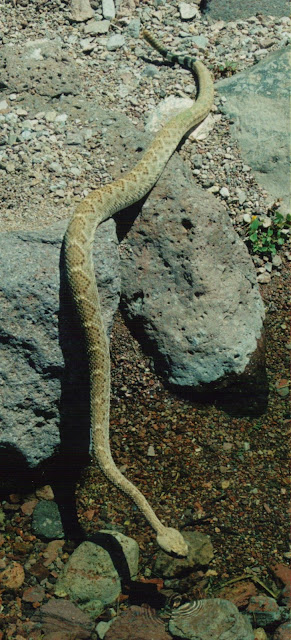
After traveling 5 miles east on the dirt South Puerto Blanco Drive, the 4.3 mile road into the Senita Basin turns off to the right. This road did not exist when I first started visiting OPCNM and I've only taken it a few times. One benefit is that it leaves the Mexico border in the rear view mirror which increases the likelihood of seeing wildlife. I have seen a western diamondback rattlesnake crossing the road
 |
| Western diamondback rattlesnake on the Senita Basin road. |
and of course like seeing the senita cacti, the only place in OPCNM that they are found (they are common in El Pinacate y Gran Desierto de Altar Biosphere Reserve south of the border in Mexico).
 |
| The ends are often covered with what looks like hair or rot, but is actually hundreds of spines. The spines protect the cactus from the sun.. |
Also, near the end of the road is a blue flag which identifies a water source for illegal aliens. It connects to a blue barrel full of water.
 |
| Blue flag off the Senita Basin road. |
 |
| It is connected to a blue barrel full of water. |
Bates Well Road:
The
Bates Well Road goes through the northwest corner of OPCNM. It is accessed 2.2 miles southeast of Ajo on Hwy 85 by the dirt Darby Well Road going southwest, just south of the tailings of the New Cornelia Mine.
 |
| Signage on Hwy 85 |
 |
| A desert thunderstorm ahead as I was coming back down the Bates Well Road toward Ajo. The New Cornelia Mine tailings are to the left. |
You follow it for 11.9 miles to the OPCNM boundary. Continuing on 3.8 miles inside OPCNM is Bates Well, to the left.
 |
A zebra-tailed lizard on a post leading into the Bates Ranch.
|
Continuing on 5.9 miles later the Pozo Nuevo Road goes southwest to the left. Continuing on, the OPCNM boundary is 2.5 miles and then the road passes into Cabeza Prieta NWR.
 |
| Right near the boundary of OPCNM and Cabeza Prieta NWR is a U.S. Border Patrol station. The Border Patrol is the biggest presence in the park, bigger than other visitors. |
 |
| One of the vehicles inside the fence. |
 |
| There are a couple of stations along the road targeted for illegal aliens entering into the U.S. |
 |
| A message at the station. |
 |
| Food at the station. |
I was hoping to see the highly endangered pronghorn antelope, but saw none. Aside from the zebra-tailed lizard I did not see any other significant wildlife. Agua Prieta NWR is a better place to see the pronghorn antelope so I'll probably make no further attempts to drive the Bates Well Road.
Pozo Nuevo Road:
The Pozo Nuevo Road is a rough dirt road that extends 14 miles from the Bates Well Road south to the North Puerto Blanco Drive just north of Quitobaquito Spring.
I've only been on it once, in August 2017 when I went south from the Bates Well Road about 5 miles until I had to turn around because the non-four wheel drive vehicle I was driving did not have sufficient clearance or traction.
Various Cacti:
The saguaro cactus is probably the most well known of the cacti and OPCNM has lots of them.
 |
| Saguaro cactus |
 |
| In bloom, the saguaro sports a white flower which emanates from an arm. |
 |
| The flower wilts and turns into a fruit that is green, then turns red and eventually bursts, spreading its seeds onto the ground. |
 |
| Some green fruit turning red, and some fruit that has already ripened, opened and scattered its seeds. |
 |
| Birds also help scatter the seeds. When I visited while the saguaro were fruiting, I saw white winged doves everywhere. I normally do not see white-winged doves there. |
 |
| A ripe fruit that has been cut in half. The seeds are quite good. |
The organ pipe cactus is what the national monument is named for.
 |
| The organ pipe has many arms, looking somewhat like the pipes of a large organ. |
 |
| It too has white flowers. |
 |
| The white flowers eventually turn into round green fruit covered with lots of spines. Here one of the fruit has burst open showing the reddish insides and fruit. |
 |
| Green and red organ pipe fruit on the ends of the arms. |
 |
| An organ pipe fruit that has burst open and deposited its seeds. |
 |
| A fruit that I've removed and cut open. The inside fruit is slightly sweet and very good. |
The chain fruit cholla can get quite tall and has large bundles of fruit.
 |
| Chain fruit cholla |
 |
| Good view of clusters of fruit. |
 |
| I'd never seen the flower on a chain fruit cholla until I visited OPCNM in August 2017 (much later in the year than I'd ever visited). I still have not seen the ripe fruit. |
The hedgehog cactus is long, like a cucumber and grows in clumps.
 |
| This group of hedgehogs was found in Grass Canyon. |
 |
| The flowers on the hedgehog are gorgeous. |
 |
| Fruit on hedgehogs that have replaced the flowers. |
 |
| Inside one of the fruits. They look and taste like the dragon fruit. |
I've seen buckhorn cholla with three different colors of flower: orange, yellow and red.
 |
| This buckhorn cholla is near the Alamo campground. |
 |
| Orange buckhorn cholla flowers. |
 |
| Yellow buckhorn cholla flower |
 |
| Red buckhorn cholla flowers. |
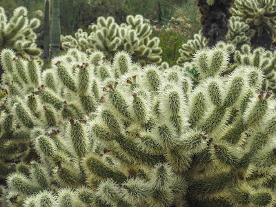
The teddy bear cholla is one of my favorites.
 |
| Teddy bear cholla along the Ajo Mountain drive. |
 |
| Flower of the teddy bear cholla. |
The fishhook cactus is very tiny and sometimes hard to spot.
 |
| They are often solitary, but this one is in a group. These were found in Estes Canyon. |
 |
| This flowering fishhook was actually in Joshua Tree National Park, the only place I've ever found them flowering. |
The
Sonoran barrel cactus is only found in a small part of the U.S., from Ajo, Arizona south into Sonora, Mexico. This one was photographed just off the South Puerto Blanca road near the Mexican border.
The California barrel cactus, with yellow flowers, is also found in OPCNM.
This prickly pear cactus was found in Alamo Canyon. It had a yellow flower and red fruit. The seeds inside were huge and hard as rocks.
 |
| Prickly pear cactus |
 |
| I cut the fruit in half with a knife. |
 |
| The seeds are spread out on the hood of my car. |
The silver cholla:
Mexican Gold Poppy:
In a good rain year, the Mexican gold poppy can blanket OPCNM and make it spectacular.
 |
| Along the Ajo Mountain Loop |
 |
| Estes Canyon |
 |
| The colors on the poppy can vary. |
Other Various Trees and Plants:
For most of the year the palo verde tree is a bare green tree. However, when it flowers it has gorgeous yellow flowers that complement the green wood.
 |
| Palo verde tree with some flowers. |
 |
| This palo verde is full of flowers. |
This desert thorn with red fruit was found near Quitobaquito Springs.
This velvet mesquite was found near Quitobaquito Springs.
 |
These catkins are tiny clusters of yellow flowers that turn into seed pods.
|
 |
| The catkins turn into green seed pods, then dry out. These are drying out. |
The ironwood tree has extremely hard wood and is often used in Mexico for carved souvenirs.
 |
| This is a flowering ironwood tree in OPCNM. |
 |
| Flower on ironwood tree. |
A Baja fairy duster on Puerto Blanco Drive:
An agave:
Chuparosa:
 |
| At the visitor center. |
 |
| In Estes Canyon |
Creosote:
 |
| A creosote where it has flowered and the flowers have turned to seeds (white fluffballs). |
 |
| Creosote blooms. |
Ocotillo:
 |
| This ocotillo was actually photographed in Joshua Tree NP, but it is the same plant found in OPCNM. |
OPCNM is wide-open and relatively unknown. If you like the desert, real desert, and solitude, you will find all of that in spades.


This is an amazing post, covering so many visits, animals, and plants. You have some amazing photos. I think the camping trip we took there in 1990 was a favorite for the kids. Your many sightings of rattlesnakes reminds me of one of the reasons that I always worried about you being there--which you often were.
ReplyDelete