Tuesday, September 24, 2019

White Butte - North Dakota High Point

The day after our 40th anniversary, Judy and I hiked to the top of White Butte, at 3,506 feet, the high point of North Dakota. Ten years previously, the day before our 30th anniversary, we hiked to the top of Mt. Elbert, at 14,433 feet, the high point of Colorado and the second tallest mountain in the contiguous U.S. The difference in hikes in that ten years may say something about my age and fitness level. 

According to one previous hiker, White Butte is 45 miles northeast of the southwest corner of North Dakota; 6.5 miles south and 1 mile east of Amidon, population 20 in the 2010 census; and by my estimation, 36 miles south of the eastern boundary of Theodore Roosevelt National Park, South Unit.  
This sign is in Amidon and points to a dirt road going south. 
The biggest challenge to climbing White Butte is finding it. Our directions took us down a dirt road that was closed due to flooding and road construction. At that point I thought we'd been stymied, but after getting directions from a person we flagged down driving on the road, and subsequent directions from another person at a house nearby White Butte, we found the trailhead. 
White Butte from near the home we stopped at to ask directions. The high point is the little knob to the left of the summit plateau. 
Sign at the parking area.
This photo was taken from the summit and looking back toward the trail head. Our car is parked near the northeast edge of the most green field to the center/left. Following the edge of that same green field and a dirt road to the south you see a clump of several large green trees. The abandoned farm house is in front of those trees. If you follow the road further south, you can see men in orange vests getting out of a truck. They are about two-thirds of the way from the farm house to the trail head. 
This is a view of the summit from near our car. The summit is to the right on the ridge from the biggest knob to the left. 
The next challenge was due to expectations. We got there about 3:45 p.m. and a couple who had just come back from hiking it said that they had gotten very muddy, climbing up some clay hills that were quite steep, and that it had taken them three hours. They believed it was a six mile round trip. My information from Summitpost said it was 3.4 miles round trip. Judy was not happy with me because of this new information and I was not particularly excited about a 6 mile hike this late in the afternoon either. 

For awhile, I thought the map and directions from Summitpost were approaching it from south to north, and we were going north to south. I thought that accounted for the discrepancy in mileage. It wasn't until we were half-way into the hike that I determined we were on the right route. The couple before us had wandered off the trail and created much more work for themselves. 

From the parking area, just off a nicely graded dirt road that bends from west to north, you follow a fence line south on a much less well developed dirt road. 
This photo, taken with a telephoto lense from the summit, shows the abandoned farm house in the foreground and our vehicle behind it near the far edge of the greenest field behind it. 
.7 miles from the parking area you pass an abandoned wood farmhouse on the right. When I saw the farmhouse, I knew we were in the right place. 

.3 miles further you reach the trailhead which is through a gate, with a sign. That area was very muddy. 
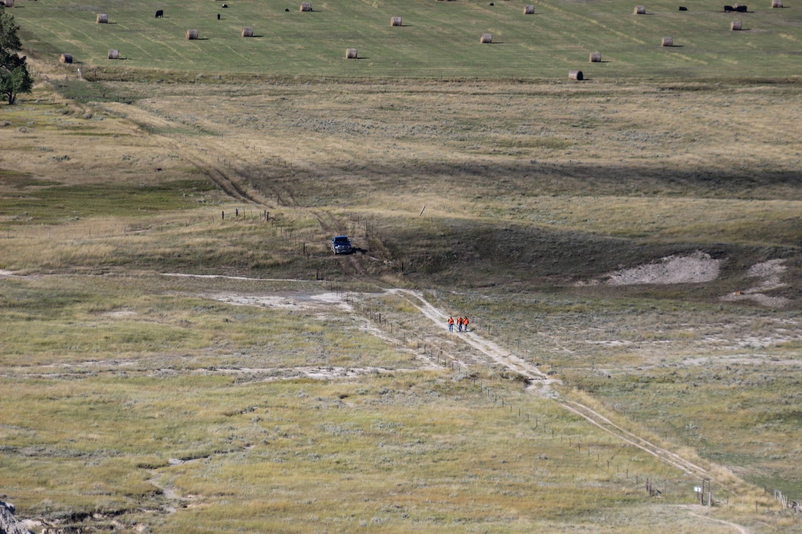
This photo, taken from the summit, shows the trees next to the abandoned farm house at the back, top left. Three men in orange vests are walking on the dirt road and their truck is behind them. The trailhead is near the top right (the white trail head sign is visible). 
The trail head sign.
White Butte from the trail head. 
.2 miles from the trailhead you reach a sandy wash and the trailhead keeps going mostly straight south, to the west a bit and then to the south. The couple we'd talked to had wandered west too much at that point and up some steep muddy banks. We wound around uphill, getting out of the white clay and eventually reached green grass and a downed barbed wire fence which was .1 miles beyond the sand and mud. 
Looking back. The clay cliffs to the west stay to the west. 
From there it was .3 miles to the summit, first along up a big knob on the left that I thought was the summit, but then stretching to the southwest along a ridge to a smaller knob that was the high point. 
Beyond the clay and into green fields. The east knob is visible in the background. 
Looking back, across the green field we crossed. We are nearing the east knob. 
Looking back, we have now bypassed the east knob and are heading to the ridge. 
Looking ahead, the summit knob is in front of us. 
The summit knob. 
We made it to the top in about 42 minutes and Judy was happy with me again. At the top is a round geological survey marker, a metal green ammo box with a summit register and a cardboard sign with "North Dakota" written on it, and a the grave of Lawrence P. Buzalsky (1935 to 1990), a member of the family that previously owned the land. Ten years previous on Mt. Elbert, we'd met three men that were scattering a portion of the ashes of a buddy who'd died. I guess we all want to go as high as we can when we die, and the high point is about as good a physical realization of that as you can find (I've been to Death Valley, the low point of the U.S., and no one was clamoring to spread ashes or be buried there). 
The grave stones, metal ammo box and geological marker are to the left of Judy. 
Mr. Luzalky's grave marker. 
We noticed a truck that drove most of the way down the road we'd walked, almost to the trailhead. Three guys in orange vests got out and started hiking the way we'd come. We later passed nearby them and determined they were hunters (their truck cabin was full of bows and arrows). 
Terrain on the other side of the high point, to the south.
Terrain to the southwest.
After about 10 minutes on top, we started back down and were finished in about 1.5 hours total. 

It was less secluded than I'd imagined from my reading, and more green. Like other high points we've done, it took us into a part of the state we would not otherwise have gone and gave us a different perspective of the state. 

Monday, September 23, 2019

Wild Horse

We encountered some wild (feral) horses in Theodore Roosevelt NP near Medora, North Dakota. I did a post on wild horses nine years ago which gave some background on them. 

According to literature handed out by the NP Service, they initially tried to remove all of the wild horses from the park. Then, in 1970, they changed policy, recognizing that the horse was part of the historical setting. Now they allow some horses in the park, but remove some on a regular basis using tranquilizer darts and then they are sold in online auctions. 
The same literature quotes Theodore Roosevelt in the 1880s, who ranched in the area which is now the park: "In a great many - indeed, in most - localities there are wild horses to be found, which, although invariably of domestic descent, being either themselves runaways from some ranch or Indian outfit, or else claiming such for their sires and dams, yet are quite as wild as the antelope on whose domain they have intruded." 
We saw horses several times. The first was as a backdrop to a very large prairie dog town. Then later, at a great distance, one ridge over from a herd of bison. The next morning when I went before sunrise, I saw them again near the same prairie dog town, then later, just off the road, grazing in the grass.  

Sunday, September 22, 2019

American Pronghorn

I've posted on the pronghorn twice previously, the first in 2009 and the second five years later in 2014 after a visit to Custer State Park in South Dakota. It has been another five years and we've been to the Dakotas again, this time North Dakota, so time for another pronghorn post. 
My first and best encounter was a male and two females just east of Hwy 85 north of Belfield. I spotted them in a field while driving, parked on the side of the road and got out and surprised them as I crested a small bank that prevented them from seeing our parked car. The male stared for a few seconds before taking off and taking the two females with him. 


I wanted to see some more pronghorns and with limited time I drove 20 miles west of Hwy 85 into the Little Missouri National Grassland, northeast of the South Unit of Theodore Roosevelt National Park. There I encountered two solitary pronghorns, one a small female and the other a young male, within several hundred yards of each other. My photos of these are not very good, so I've not even included one of the young male. 
I am thrilled every time I see a pronghorn. 

Index - Nature Destinations

Azerbaijan:    

Belize:
     Caye Caulker
     Xunantunich
 
Botswana:   

Brazil: 
 
Canada:  

     New Brunswick   
          Maliseet Trail to Hays Falls  

     Nova Scotia:  
          Bird Islands of Cape Breton  

     Yukon:   
          Yukon Wildlife Preserve   
 
Colombia:    

Ecuador:    
     Mashpi Amagusa Reserve    

Greenland: 

Guatemala:
     Finca El Pilar  

Iceland:  

India:

Indonesia:   

Jamaica:
   
Kenya:   

Morocco:  
     Erg Chebbi Dunes  

Namibia:

Peru:  

Portugal:  
     Sado Estuary  
     Tagus Estuary  

South Africa:  
     Boulders Bay   
     Cape of Good Hope   

Sri Lanka:  
     Anuradhapura  
     Kandy Lake   
     Polonnaruwa   
     Yala National Park   

Tanzania:
     Ngorongoro Crater   

Uganda:
     Nkima Forest Lodge    
 
U.S.A.: 
 
     Alaska:   
          Denali National Park and Preserve   
          Gull Island - Kachemak Bay  
          Kenai Fjords National Park  
 
     Arizona:
          Organ Pipe Cactus NM  

     California: 
          Alondra Park Lake   
          Back Yard Birdfeeder - Redlands  
          Batiquitos Lagoon  
          Big Morongo Canyon Preserve  
          Bolsa Chica Ecological Reserve   
          Corn Springs  
          False Klamath Cove    
          Ford Park - Redlands   
          Humboldt Bay NWR  
          Irvine Regional Park    
          Lake Hodges - near Escondido   
          Lake San Marcos  
          Lake Tamarisk - Desert Center   
          Live Oak Canyon Herngt 'Aki' Reserve  
          Los Angeles County Arboretum  
          Mojave Narrows Regional Park   
          Santa Fe Dam Recreation Area  
          Silverwood Lake 
          Sonny Bono Salton Sea NWR   
 
     Colorado:
          Mount Evans
          Pawnee National Grassland  

     Florida:
          Circle B Bar Reserve
          Merritt Island NWR
          Orlando Wetlands Park
          Viera Wetlands Storage Ponds

     Georgia:
          Okefenokee NWR

     Kansas:   
          Cimarron National Grassland   
 
     Louisiana:   
          Cameron Prairie NWR  
          Sabine NWR  
 
     Minnesota:    

     New Mexico:    
          Bitter Lake NWR  
          Valles Caldera National Preserve 
          White Sands National Park  
 
     New York:   
          Central Park - New York City      
          Kaaterskill Falls 
          Letchworth State Park   
          Montezuma NWR  
          Sapsucker Woods 
          Watkins Glen State Park 

     Oregon:   
          Wildlife Safari - Winston  

     Texas:   
          Aransas NWR  
          Balcones Canyonlands NWR  
          Brazoria NWR 
          Buffalo Lake NWR  
          Caprock Canyons State Park   
          Concho River Walk - San Angelo   
          Padre Island National Seashore 
          McKinney Falls State Park    
          Palo Duro Canyon State Park        
          San Angelo State Park   

     Utah:
          Antelope Island
          Bear River Migratory Bird Refuge  
          Fish Springs NWR  
          Hardware Ranch

Zimbabwe:
     The Hide, Hwange National Park   

Saturday, September 21, 2019

Coyote

I did a post on the coyote ten years ago. Since then I've not seen nearly as many of them. Part of that is our travel has been more international, and I've spent less time in our local deserts and mountains. Part too, is the area where we live has been built up and there are fewer open fields to encounter them in. 
Earlier this month we spent our 40th anniversary in North Dakota. One early morning while Judy slept in, I got up early and drove into Theodore Roosevelt NP and was there driving when the sun came up. The coyote in these photos was trotting along the base of a hill in the early morning light. I was using a camera setting with a slower shutter speed to get more light. As a result, the coyote was a little blurry in most of the photos I took. 

It was very fun to have a nice view of a coyote again. 

Friday, September 20, 2019

Swainson's Hawk

While taking an unplanned side trip to see the world's largest holstein cow, standing on a hill in New Salem, North Dakota (made out of fiberglass), my attention was focused on two hawks that were in the air and riding air currents into a swift wind, standing still much of the time. I thought they were falcons because the wings appeared pointed, but in identifying them later I suspect it was the wind bringing the feathers together into more or less of a point. 
They were Swainson's hawks which I've seen once before, in Colorado, but a dark morph version. These were light morphs, which are much more common, about 90% of them. The adult has white underparts, a reddish bib on the chest, a white throat and face patch. The leading edge of the underwings in flight are light and the trailing edge of flight feathers are dark, which is unique among North American raptors. The tail is gray-brown with about six narrow dark bands and one subterminal band.  
My photos are all from underneath and don't have much variation. 

Thursday, September 19, 2019

Royal Tern

I saw my first royal terns while in a small motor boat in the lagoon between South Padre Island and the mainland of deep southern Texas, just off the Gulf of Mexico. 
Royal terns
There are two subspecies: (1) the one we saw, Thalasseus maximus maximus, the nominate subspecies, which is found along the coast from southern California to Peru and Florida and the West Indies to Argentina; and (2) T. m. albididorsalis, found from Mauritania to Guinea in Africa. 

Royal tern sandwiched between two Caspian terns. 
It has an orange-red bill, pale gray upper parts, white under parts, black legs, and a black cap during breeding season which becomes patchy otherwise. They were mixed in among Caspian terns and were initially hard for me to distinguish.