Victoria Falls is touted as one of the
seven natural wonders of the world. When we visited Victoria Falls last year we wanted to get a feel for it from as many different perspectives as we could. So my post on Victoria Falls included a canoe trip down the Upper Zambezi, a sundown boat ride on the Upper Zambezi just above the falls, walking along the cleft of land opposite the falls, and a helicopter ride above the falls.
Jakobshavn Glacier, and
Ilulissat Icefjord which transports the calving glacier ice to the open ocean, is another significant natural wonder of the world, which awed me just as much as Victoria Falls. It was declared a UNESCO World Heritage Site in 2004. I'm going to cover the Glacier and Icefjord from multiple perspectives as well: (1) an evening walk with my law partner, John, along a trail from the southern end of Ilulissat out to where the Iceberg Bank meets the mouth of the Icefjord on the north side; (2) a morning guided tour where we followed a boardwalk out to the northern edge of the Icefjord, within the Icefjord; (3) an evening boat ride out into Disko Bay along the edge of the Iceberg Bank, from about 10:00 p.m. to 12:30 a.m.; (4) an afternoon boat ride out into Disko Bay along the edge of the Iceberg Bank, from about 4:00 p.m. to 6:00 p.m.; (5) a one hour flight with AirZafari out over the ice sheet, to Jakobhavn Glacier, and then down the Icefjord, leaving about 9:00 p.m.; and (6) a one and a half hour flight out over Disko Bay and the southern portion of Disko Island, then over the Iceberg Bank, leaving around 7:30 p.m. I also got a good view of the Icefjord on our flight out from Ilulissat to Kangerlussuaq. In many ways this is a continuation of my post on the
Greenland ice sheet.
 |
| Out over the Greenland ice sheet by air. It is hard to distinguish the ice from the sky and it goes on forever. |
 |
| The Greenland ice sheet. |
Jakobshavn Glacier, also known as Ilulissat Glacier, Jakobshavn Isbrae (in Danish) and Sermeq Kujalleq (in Greenlandic), which I'll refer to as the "Glacier," is the fastest moving and most productive glacier (in terms of icebergs produced) in Greenland. It drains 6.5% of the Greenland ice sheet and produces 10% of all Greenland's icebergs. To get an idea of how significant this is, if all the ice that flows through the Glacier were to melt,
global sea levels would rise almost two feet. The Glacier calves into Ilulissat Icefjord, also known as Ilulissat Kangerlua (in Greenlandic), which I'll refer to as the "Icefjord." The Icefjord is about 34 miles long from the foot of the Glacier to its mouth where it empties into Disko Bay, which is an inlet of Baffin Bay, part of the
Arctic Ocean. A shallow threshold or sill, known as the Iceberg Bank, near the mouth, traps the calving ice and backs it up all the way back to the Glacier so that the Icefjord is a white melange of icebergs and glacial ice.
 |
| View of the Iceberg Bank in the front, then back as far as you can see, down the Icefjord, toward the Glacier. All of that white is icebergs and glacial ice. |
 |
| On our Air Greenland flight to Kangerlussuaq. Looking down the Icefjord toward the Glacier. Large icebergs stick up out of the melange. The water of Tasiusaq is to the right at the upper right of the photo. |
Jakobshavn Glacier is part of the massive Greenland ice sheet, but is also considered to be an ice stream, an outlet glacier and a tidewater glacier as well. It is (or was) about 40 miles long and a mile deep, but I don't know how you determine where the head of the glacier begins when it is a part of something much larger than itself (the ice sheet)? I believe that the Glacier begins where the ice stream begins. A description found in the
UNESCO application (which is great because it is so detailed, but now inaccurate as the Glacier has retreated significantly since then) states that the ice stream is situated in a very deep trough which eventually evens out to the height of the surrounding terrain as it heads east. The trough was about 1.2 miles deep at the
grounding line, which is the point where a tidal glacier leaves land and begins to float. The suspended platform of ice that forms over the water surface beyond the grounding line is known as an
ice shelf. The ice shelf at the time the UNESCO application was prepared was about 9 miles long. The ice surface above the grounding line was about a quarter mile above sea level.
 |
| Illustration of grounding line and ice shelf, from here. |
The trough got deeper than 1.5 miles about 25 miles east of the grounding line where the ice surface above it was about six-tenths of a mile above sea level. About 31 miles east of the grounding line the trough leveled out to the height of the surrounding terrain. If you take the 9 mile ice shelf and the 31 miles beyond the grounding line, you get the 40 mile estimate for the length of the Glacier. Unfortunately, the
ice shelf disintegrated in the early 2000s, which both grounded the face of the glacier and sped up its retreat. The Glacier retreated 10 miles in the 100 years between 1900 and 2000. From 1955 to 1985 it was in balance. After 1997 the retreat accelerated to about 112 feet per day and it began to thin rapidly, up to about 49 feet per year. In the 10 years from 2000 to 2010, it retreated 9 miles.
 |
| From Wikipedia, showing the retreating Glacier over time (to 2006). Also note the Iceberg Bank as outlined by the glacial ice at the far left side; Sermeq Avannarleq and Sikuiuitsoq in the top middle; and Tasiusaq in the bottom middle. |
In 2012, the retreat accelerated to three times the speed of the 1990s, to about 10.5 miles. That year a group of photographers filmed a sequence of 7.4 cubic kilometers of ice calving off the Glacier which took 75 minutes and is the longest calving event ever filmed.
See this amazing video of it which has had over 56 million views. The filmers created a documentary called
Chasing Ice and compared it to watching the lower tip of Manhattan calving off the Glacier, except the glaciers were 2.5 to 3 times taller than the buildings on Manhattan. On February 15, 2015 there was a calving event of 7 square kilometers and on August 16, 2015 another calving event of 12.5 square kilometers, identified by satellite, the largest calving event ever recorded at the Glacier.
A climate pattern called the North Atlantic Oscillation causes the northern Atlantic Ocean to switch slowly between warm and cold every 5 to 20 years. Fortunately, the climate pattern which has caused the Jakobshavn Glacier to be the fastet-flowing and fastest thinning glacier in Greenland for the last 20 years switched in about 2016 and the water in the ocean current now reaching the Glacier face has cooled to levels not seen since the mid-1980s and the Glacier has now thickened and advanced three years in a row.
This great video from NASA describes the newly changing ocean temperatures at the Glacier and gives some great film footage and animation of the Glacier, the Icefjord and Greenland.
As alluded to previously, the foot or end of a glacier, the glacier front, is where the calving takes place. The glacier front of Jakobshavn at the time of the UNESCO application was about 4.7 miles. The mean thickness of the ice on the Glacier front was about 2,460 feet (.47 miles). The height above sea level of the Glacier front was between 130 and 295 feet along the north to south portions and 65 feet along the east to west portions.
 |
| Calving front of Jakobshavn Glacier by John Sonntage of NASA, found here. Look closely to the upper left of the two rock ridges that are the outer rock band of the Icefjord. You will be able to identify the Glacier front which crosses the upper end of the Icefjord, now beyond the rock bands. Also note a huge iceberg in the Icefjord toward the bottom right. |
 |
| A much closer view of the Glacier front in the center, the melange of ice in front of it, and the Glacier extending behind it. This was taken on our flight with AirZafari. The melange of ice and glaciers in the foreground of the Glacier front is so thick that it is difficult to differentiate where the Glacier ends and the Icefjord begins. |
 |
| Another photo, as above. |
 |
| Crevasses and blue ice behind the front of the Glacier. |
 |
| More of a side view of the Glacier front, with the ice melange to the left. The scale of what we are looking it as so large that it is hard to contemplate. |
The calving at the front of Jakobshavn produces the icebergs in the Icefjord. Due to the shallow Iceberg Bank at the mouth of the Icefjord, the large icebergs get stranded there and accumulate in the Icefjord. The icebergs vary considerably from large mountains of ice more than 328 feet above sea level, to small pieces. Only about one-ninth of the size of the iceberg is visible above water, the remaining eight-ninths remains invisible below water.
 |
| Huge, bowl shaped, iceberg. |
 |
| A seal pokes its head out of the water in front of huge icebergs. |
 |
| A man in a small motor boat passes by huge icebergs. |
 |
| Reflection of mountainous iceberg in water. |
 |
| Another iceberg reflection. |
 |
| A large iceberg with sun nearly setting in early morning sky. |
The Icefjord is covered in ice year-round. From June to September it is filled with brash ice and icebergs. Brash ice is accumulated floating ice made of fragments not more than 6.5 feet across. We learned this lesson when we took a walk up to the edge of the Icefjord and looked out at the expanse of white. It looked like something you could walk out onto and explore.
 |
| Walking up to the north edge of the Icefjord. |
 |
| Looking more to the east, more in the direction of the Glacier. |
 |
| Looking straight across the Icefjord to the south side. The mountain just visible to the back left is the other side of the massive Icefjord. |
However, when we walked up to the edge of the Icefjord and looked down, we could distinguish the brash ice and see it was floating on water.
 |
| Looking down into the water from the northern edge of the Icefjord. It no longer looks solid. |
 |
| Flying over the Icefjord just below the Glacier face, heading west. Gaps in the melange reveal water. |
 |
| More ribbons of water in the melange. |
The rest of the year, October to May, the Icefjord freezes and the locals take dog sledges out on to the ice and hunt seals and fish for halibut.
Air bubbles in ice give it a whitish color. The glacier ice, particularly the ice near the top or upper layers of the glacier, is rich in air bubbles which gives it the white color. The incredible pressure created by glacial ice squeezes the air bubbles out of the lower ice, increasing the density. The denser ice absorbs other colors more efficiently than blue, which gives it a blue color. The blue color is also created by freezing melt water which accumulates in crevasses in the ice sheet. The blue on the ice sheet, in the crevasses near the Glacier front, and in the icebergs floating in the Icefjord and in Disko Bay were things I looked for and focused on. Many of my photos tried to capture the areas of blue.
 |
| A blue water melt lake on the ice cap. |
 |
| Blue melt water filling crevasses in the upper Glacier. |
 |
| A very blue iceberg backed up behind the Iceberg Bank. |
 |
| Spiky blue sentinels. |
On our boat excursions into Disko Bay just beyond the Iceberg Bank, our guides captured ice and brought it on board for us to taste. When the white ice, full of bubbles is put into a bucket of water, it starts to pop. You can hear it and feel it when you put it in your mouth. The denser blue ice does not pop and creates much more melt water from the same mass of ice. We could actually hear the popping sound of the bubbles from the white ice in the bay.
To the north of the Icefjord is another glacier, Sermeq Avannarleq, which has a connecting fjord,
Sikuiuitsoq or Sikujuitsoq, to the Icefjord. We flew over Sermeq Avannarleq, which is not a calving glacier, on one of our flights, and it has an impressive glacier wall.
 |
| Sermeq Avannarleq, looking from the north to the south toward the fjord in front of it. |
 |
| Looking down at the glacier face of Sermeq Avannarleq. Lots of crevassing and blue ice. |
 |
| Crevassing above the glacier face. |
South of the Icefjord, almost immediately opposite Sikuiuitsoq, is another fjord, or at least a water basin of some sort which has various branches, known as Tasiusaq, which we saw from the airplane from a distance. One of the things I wondered about as we flew over those areas was why the icebergs and brash ice remain jammed in the Icefjord and do not flow into either of those water systems, particularly Tasiusaq, because it is quite extensive. I suppose the fact that neither of them has an outlet to Disko Bay and they are likely flowing into the Icefjord may be the answer.
 |
| Looking over at the open water of Tasiusaq. |
 |
| Closer view of the entrance or exit from Tasiusaq. |
The depth of the Icefjord varies. The UNESCO application estimated the depth of the Icefjord at the confluences of Sikuiuitsoq and Tasiusaq to be between 3,280 feet (.62 miles) and 4,921 feet (.93 miles). At the mouth of the Icefjord is a shallow threshold or
sill known as the Iceberg Bank. It has an average depth of 650 feet (200 meters). The deepest point, 820 feet (245 meters), is a saddle on the northern edge of the sill. A shallow ridge, averaging a depth of about 328 feet (100 meters) forms the southern side of the sill. The Iceberg Bank is arch-shaped and stretches out into Disko Bay. Any iceberg with a depth deeper than the Iceberg Bank gets stranded on the Iceberg Bank and languishes there, typically between 12 and 15 months. The iceberg remains there until the depth of the iceberg is reduced sufficiently by melting, or until the pressure from the ice in the Icefjord becomes so great that the iceberg is forced over the Iceberg Bank into Disko Bay.
 |
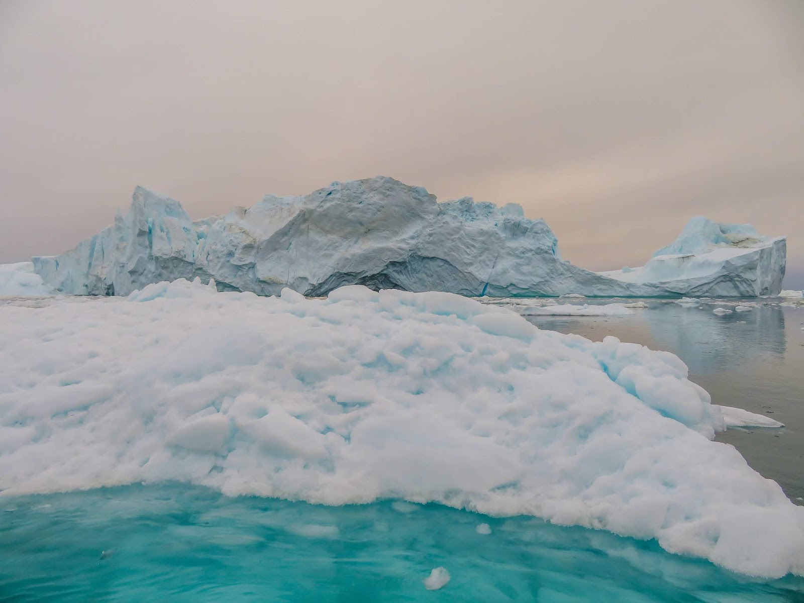
| On my walk with John we encountered these large icebergs trapped at the Iceberg Bank near Ilulissat. |
 |
| This is a more wide-angled view. |
 |
| This view, from near the Hotel Arctic in northern Ilulissat, shows the icebergs trapped by the Iceberg Bank as it arcs out into Disko Bay. |
 |
| I similar view as above, in less bright light, captures a wider angle of the Iceberg Bank as it juts out into Disko Bay. |
 |
| From the air, large icebergs delineate the underwater Iceberg Bank. In the background is Ilulissat sandwiched in between the first two rock projections. The icebergs to the upper left are the same ones we were seeing from the ground from the Hotel Arctic. |
 |
| Looking down on the large icebergs being held up by the Iceberg Bank. Ilulissat is to the left on the land visible at the top of the photo. |
 |
| The icebergs along the Iceberg Bank, looking toward the south side of the Icefjord. |
 |
| The icebergs of the Iceberg Bank, looking north toward Ilulissat. |
 |
| Huge icebergs from the air. |
 |
| Humpback whales both spouting, as seen from the air near the Iceberg Bank. |
I've learned a lot about glaciers and icebergs going through this exercise of trying to understand what we were seeing in and near Ilulissat. It remains one of the most amazing things I've ever seen.


Wonderful photos and a very educational description. Some of the photos look like the setting for a sci fi movie. I love that video of the calving glaciers. It makes me wonder if that is what will happen when the San Andreas Fault finally goes--one unstable area leads to another, etc.
ReplyDelete