One of my favorite winter camping and hiking destinations over the years has been the Mecca Hills, at the far end of the Coachella Valley just north of the Salton Sea. I have been there about seven times over the years, usually in November or February, with both scout groups and family. The itinerary is usually about the same. Friday evening we drive to Painted Canyon. From Mecca, take Box Canyon Road four miles east past the Coachella Canal, then left on to the dirt "Painted Canyon" road. Four miles down the good dirt road (despite the sign recommending four wheel drive) you enter Painted Canyon and about another two miles in you reach the end of the road. I have camped every time near the end of the road, although on my most recent trip in November 2010, we found that they have restricted camping at the very end, but we only had to pull back about 50 yards. It is a wonderful place to car camp. Below, a scout group in November 2008.

There is so little vegetation that there is not much worry about fire. We bring plenty of wood and get a good roaring fire going. Below, Mark Martinsen, Sam and Andrew in February 1996.

I particularly like to bring a foil dinner which I can cook in the coals. The ground is relatively flat and the dark, closed in canyon, provides a wonderful setting for tales around the campfire. Some of my favorite blah stories have originated in the canyon, including Kit the Indian that turned into a fox (a year we had foxes running through our campsite)

and the story of the man-otes, Indians that morphed into coyotes and roam the canyon after dark. Twice, early on, we were visited by gray foxes running through camp and stealing our food.

After the first visit, the next time we came we brought bread and through it out for the foxes, and they gobbled it up. Unfortunately, I've not seen the foxes the last three or four times I've been there.
The first time I visited was November 1st and 2nd, 1991. I was scoutmaster, with a group of scouts, including two of the Burdette triplets, Damian and Larry Gray, Jeremiah Brice, Bobby Brown and Mark Richey, who was the blazer leader. The road was not closed off and we were able to drive quite a bit further into the canyon than you can now. From the current end, we drove further north and into clay hills that read like a textbook on erosion.

We could easily see how the wind and water has sculpted the hills

and the boys loved climbing up and down them.

From the current end, we also took the canyon to the east. Ladder Canyon is about a quarter mile in. This large rock has sloughed off the side of the wall and is found well before Ladder Canyon.

However, on our first couple of trips, we followed the canyon further and encountered high, perpendicular walls.

After the first few trips, the second morning we have always focused on doing Ladder Canyon and have not explored other portions of Painted Canyon. The other portions are fun, but with limited time, Ladder Canyon is the prize and then it is on to other sites that are also quite spectacular.
Ladder Canyon goes off the main canyon through a cleft in the canyon wall

and follows a little slot canyon which has been eroded by water. It gets its name from human-made ladders that have been placed in strategic places where access would be difficult or impossible without them. Below, Josh Zollinger and Terry Davis just beginning the hike into Ladder Canyon.

Below, a tree (and Tyler Puchalski) a short way into Ladder Canyon.

The first ladder is not far in (Sam in 1996)

and allows you to drop into the canyon (Tyler Puchalski, Josh Zollinger and Jim Moore in 2008).

After a couple of turns you then encounter the most impressive portion of the canyon, an approximate 15 foot cliff that is made passable by a large ladder (Sam in 1996).

The ladder was originally wood, but now there is a much safer aluminum ladder as well (Taylor and Terry Davis in 2008).

For anyone with a fear of heights, it offers a heart-thumping challenge, both up and down.

Another, significantly smaller obstacle (Taylor Davis, Ryan Moore and Sam Haws in 2008)

is surmounted by another ladder

Sam, Andrew and Mark in 1996

and then you follow the labyrinthine canyon

through a series

of twisting turns (Andrew in 1996)
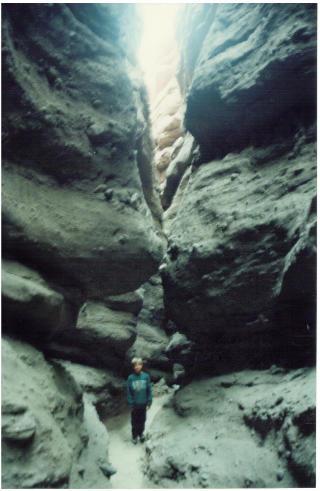
between high walls that make narrow passages.

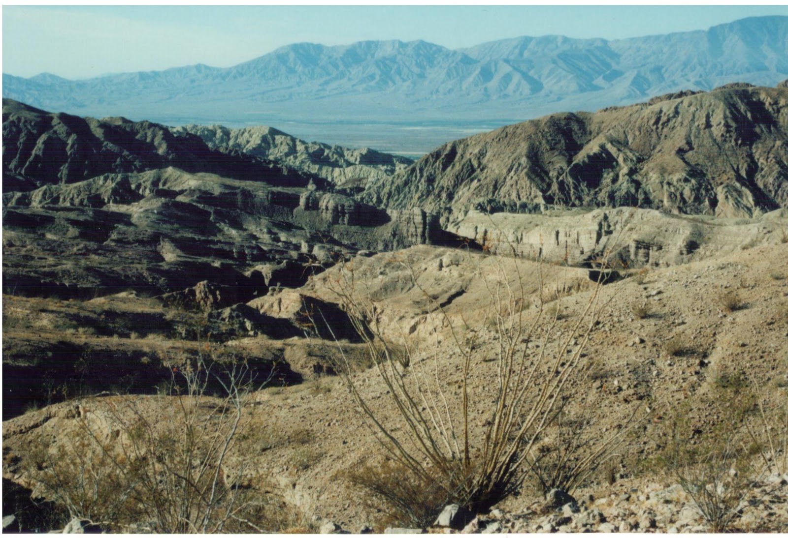
Eventually you climb out of the canyon to the top of a ridge and get a nice view of the Santa Rosa Mountains in the distance.
On my most recent visit, with the scouts in November 2010, including Jeff Zollinger, the scoutmaster, we did Ladder Canyon on Friday night with flashlights. It is the best way to do it. The canyon is even more impressive at night and we were able to do quite a bit of it by moonlight, with our flashlights off. On this latest trip, we discovered a trail in the canyon I'd not seen before. It led quite a ways and eventually at least two more ladders before emerging onto the hills behind in a different place. Because it was dark, I did not get any photos and I'm not sure where it leads out compared to the place I've gone in the past, but now I am anxious to go back again and explore this new portion of the canyon in the light. It appears this portion of the canyon has been developed relatively recently, as I've noticed that turn-off it takes, in the past, but it did not look like it had much traffic.
After completing Ladder Canyon, we pack up our gear and head back out Painted Canyon Road to Box Canyon Road. Turn left (east) and go another approximate six or eight miles to the trail into Hidden Springs, the Grotto and the Corkscrew.

From where you park (Mark Martinsen, Andrew Bonilla, David Paxman, Sam Cannon, Kevin Vines and Ken Smith in February 2000),

the trail goes a short distance up some small hills until you crest a ridge which provides a wonderful panoramic view of the southern Mecca Hills and the distant Salton Sea just beyond. In 2010, an approaching storm over the Salton Sea.

Below, Joey Lancaster, Ryan Brown, a Burdette, Damien Gray, another Burdette, Jeremiah Brice, Larry Gray and Mark Richey in 1991.

Below, Jason and Max Harker, Nathan Waddell, Jeff Zollinger, Markie Richey, Ryan Moore, Arvid Zollinger and Brent and Bowen Davis in 2010.

From there, the Sheep Hole Oasis is also visible down in the canyon to the left (the southeast).

The oasis is three or four palm trees and a dry guzzler (at least dry every time I've gone to it). The main trail follows a ridge south for 3/4 of a mile or so down into a wash running north/south. However, an alternate and faster route is to take a side trail down to the Sheep Hole Oasis and pick up the main trail further down the north/south wash. The Sheep Hole Oasis provides another point of interest on the hike that is missed if you take the main trail.
The trail takes you up and over a small ridge and then into another, east/west, wash, traveling east. The hiking is made more difficult by the sand of the wash that soaks up part of the energy of your steps and makes you work harder for your mileage. I have seen zebra-tailed lizards here before, and a desert iguana, but only when it was quite warm (in the 80's). It is usually too cool for them during the months I like to go there. For example, when we went this past November, it was in the high 60's.
After about a mile, a small canyon branching off to the left (north) into a darker colored rock leads to Hidden Springs,

a group of about 30 California fan palms (Andrew, Sam and Mark in 1996)

and a nice guzzler, see below, with small amounts of water in it.

The guzzler is used by bighorn sheep, foxes, coyotes and other animals for water which is so precious in these barren and dry hills.

This area is now part of the Mecca Hills Wilderness and motorized vehicles are forbidden.

When we first started going there in the early 1990's, we would encounter lots of dune buggies, but a large gate right before Hidden Spring prevented them from going any further and it was closed off for six months during the year so as not to disturb the bighorn sheep which wandered over for water from the nearby Orocopia Mountains. Particularly in February, the fruit from the palm trees litters the ground and coyote scat is full of the fruit seeds. Bighorn sheet tracks are also prevalent.
Back out to the east/west wash (below is multi-hued rock near the entrance to the Grotto and Hidden Spring)

traveling east, the Grotto is found up the very next canyon to the left. It is at the end of a box canyon and can be difficult to find. Below, Bowen Davis climbs up some rocks near the entrance to the Grotto.

I looked for and was unable to find it my first couple of times. I'm sure part of the issue was there is another side canyon just up the wash which can add to the confusion of finding the Grotto. To get into the Grotto, you climb up into some rocks, cross a small chasm that is crossed by a strategically placed board, and then climb down into dark cavern. A flashlight is needed. Below, Sam, David, Ken, Kevin, Andrew and Mark in 2000.

The room you enter is quite large. You follow it and it eventually opens up into a courtyard,

followed by entry into a small slot canyon where a flashlight is needed again and the passage is quite narrow. Below, Josh Zollinger and Terry Davis in 2008.

There are several places where you need to crawl to go under or climb up to go over obstacles

and eventually it opens up and reaches the other side of the ridge. You turn around and go back out the same way to get back out. The multi-hued rock near the entrance to the side-canyon leading to the grotto.

The best of all the attractions is the last one. The Corkscrew is found by continuing up the wash to the east. The wash eventually bends and starts to go south. You encounter high walls of multi-colored rocks 

with weird hues of yellow, green, pink and orange,

like a big rock candy mountain.

When you have gone about as far as you can go, you turn to your left and find a narrow cleft into the side of the mountain.

You walk in, then find a passage that you cannot negotiate without crawling on your belly.

You need a head-lamp or flashlight because once you get inside it is nearly pitch black. Below, Sam and Anddrew in 1996.

Kevin, Andrew Bonilla, David, Sam and Mark in 2000.

Ryan and Josh in 2008.

This cavern narrows and you have to be careful in several spots not to hit your head on the ceiling. About 30 yards in, you climb up some boulders and then find yourself in a narrow chute that leads straight up to daylight.

The top of the chute is about 18 or 20 feet high

and there are sufficient ledges and rock foot-holds to allow you to climb up it. This is my favorite part of the whole area. The Corkscrew is like a little miniature obstacle course. The chute is high enough and difficult enough that it strikes fear into most who climb it.

However, it is easy enough that I've not had anyone not be able to make it up it. Upon reaching the top, you find yourself at the base of the multi-hued rocks,

a great place to eat lunch, or at least have a nice snack.

If you follow a little trail you can look out over a ledge and see the wash below.

You can also hike up into the multi-hued rock, but as you get higher and it gets steeper, the footing can get tricky. Eventually, you have to go back out the same way you came in and the chute is scarier going down than it was going up.

With someone at the bottom giving guidance on foot and hand holds, each person eventually makes their way down the chute, but it can take five or ten minutes a person if they are unsure of what the are doing and need lots of guidance. The boys who have gone on ahead love to hide in the dark recesses of the cave and try to spook those coming through later. Boys are boys and their reactions are always typical. Boys love rocks and dirt, climbing into caves with flashlights, scaring each other and climbing up hills.
You now have to take the route out you came in. If it is a warm day you will need plenty of water.
This last trip, rather than going back down Box Canyon Road to Mecca, we traveled northeast on Box Canyon Road to the I-10 freeway, about 12 or 15 miles. If you keep going past the freeway, you enter into Joshua Tree National Park, Cottonwood entrance.
My husband would like to take some scouts there. He went there many years ago but cant remember how to get there. He especially wants to know how to get to the grotto and where to camp. He will be coming on the 10 freeway from Riverside.
ReplyDeleteIf you only plan to do the grotto and not Painted Canyon, I would take the I-10 freeway past Indio and take the Joshua Tree National Park exit for Cottonwood Spring. Instead of turning left and going over the freeway, turn right and go down Box Canyon Road. It was 12 or 15 miles from the freeway and will be on your left. That way you avoid all of the turns and confusing roads you normally get going through Mecca. You should be able to camp just off the road near the trailhead. I don't have an exact mileage for you. You could call the BLM and odds are there will be someone else there at the trailhead.
ReplyDeleteThese photos of the Mecca Hills and Hidden Springs brings back many childhood memories. I lived outside of Mecca and spent many, many hours riding my horse in these canyons - my dad and I found Hidden Springs way before the Boy Scouts preserved the spring for the wildlife. I am going to a CV class reunion 11/12 and am planning to trek into Hidden Springs. There used to be a large yellow rock on Box Springs Road marking the trail head into the canyons, however, if it is not there anymore, I am positive I can find my way. FYI: The grotto at the end of the canyon was easily accessible in the 60's - 80's, perhaps an earthquake rearranged the terrain.
ReplyDeleteSandra Lester Cannon
Thanks Sandra. I don't recall a yellow rock, but I'll look for it next time I go. It looks like I might be going out there with a scout group in a few weeks.
ReplyDeleteBob, that was a long time ago that the yellow rock was there. Have fun and a great adventure with your scouts!!
ReplyDeleteLoved your descriptions. I am thinking of taking some geology students there in Feb for a day trip; how much time did you spend on the ladder canyon?
ReplyDeleteMartha
Ladder Canyon itself can be done pretty quickly. If you allocate a few hours, that should be enough time to hike up from the end of the road, go through the canyon and up on top of the hill and back out.
DeleteI was in the area from Michigan on business in February, and hiked the ladder canyon trail along with some of the side canyons before my flight home. The area is beautiful and the hike was great, except when I got back to the parking area to find my rental car had been broken into & all my stuff had been stolen. I've been hiking mountains & canyons all over southern California for years when I get free time on business trips, and this is the first time I've ever had a problem. Funny thing was there were lots of people around & even some families having picnics near the parking area. I've done some checking on various websites since getting back and have found this has become a real problem recently. Just something to keep in mind for next time. I'll definitely be going back when I get a chance.
ReplyDeleteI'm sorry you had a problem. I've not had it happen yet, but I guess it is inevitable.
DeleteWent there around 1983. Best trip ive gone on. Joe was my scout leader. Tall guy with a full beard and glasses. I think it was troop 122. Thanks again joe your an awesome guy. Sincerely,john carbajal.
ReplyDeleteI'm pretty sure this is the place we went with my LDS scout troop from Riverside CA...probably around 1971. I still remember it as being one of the most fun activities of my life. Exploring the canyons and caves was so cool for a 12-year old.
ReplyDeleteThanks for all the info on painted canyon. I appreciate you sharing these places with your scouts and growing their knowledge of the natural world. However it is very bad to feed foxes human food, as well as any wild animal. They will begin to associate humans with food and this can lead to many problems. Here is a good web site that has lots of information on good camping practices: https://lnt.org/. This is all good stuff to teach to your scouts to help them become good stewards of wild places. Thanks again for the info, and nice photos!
ReplyDeleteI was just there May 4 & 5, 2018, the foxes are still there, they visited our camp site both nights we were there.
ReplyDeleteThanks for letting me know. I may have to take my grandkids out there and let them see the foxes. Great car camping place.
DeleteHi! Hey I don’t know if this blog is still active, but I was looking around for some info on the general area. my dad used to take us out to that area back in the 60s and 70s and continued visiting there for a long time without we kids as an adult, but we used to go to a place called wash 31. It was one of the washes that crossed the Coachella canal and was wondering if that is where this area is if you had any more information about wash 31 thanks
ReplyDeleteSorry, I don't know anything about wash 31 or the Coachella canal.
Delete