I previously detailed a trip into the Yankee Boy Basin to climb Mount Sneffels that ended with Dave Kenison and I attempting to climb the wrong mountain. Nearly 17 years later, on August 10, 2009, we decided to try again. It was a busy weekend. On Friday, Dave's daughter, Sarah, married Brian Wright. On Saturday, with Judy and the Wrights, we climbed Mt. Timpanogas. Sunday afternoon we got in Dave's truck and headed for Ouray and the Yankee Boy Basin. Around 11:30 p.m., after nearly a two hour drive up the horribly rutted 8 mile road, we stopped and slept in the back of Dave's truck. The road was much worse than it was 17 years ago. In fact, as I looked at pictures afterward, I was shocked to see we drove farther last time than this time. The next morning, we drove a little further and parked...
 right next to the spur trail for (appropriately) Wright's Lake and Blue Lakes Pass.
 Because our trip into the Basin was in the dark, I'd forgotten Sneffels was at the right side of the end of the Basin. For a few moments, I was thinking that Gilpin Peak, below, was Sneffels.
 Along the trail we found some beautiful columbine flowers.
 Dave said he'd never seen them with the underlying blue on them like these had.
 As we rounded a hill the hill to the right, we encountered Wright's Lake...
...and we caught our first glimpse of Mount Sneffels. A sight for sore eyes. The standard route follows the scree up to the saddle, just to the right of Dave (the well-worn path is visible), then goes left up a couloir to the summit. The southwest ridge route starts at the far left, goes behind the spires up the ridge, goes through the notch just under half way up, then follows the ridge-line to the summit. We decided to go up the southwest ridge and then go down the standard route.


 On the way up to Blue Lakes Pass, looking south at Gilpin Peak. Gilpin Peak is apparently a class 2 hike following this ridge.
 Dave getting closer to Blue Lakes Pass.
 From the summit, looking down at Blue Lakes Pass. The trail we followed is visible.
 From Blue Lakes Pass, looking up the southwest ridge. We walked up just to the left of the spires and ultimately followed the ridge to the summit. I was excited and a little nervous. I've not done a lot of class 3 climbing. This was to be my first experience following a narrow ridge to a summit.
 Dave begins the hike up the rocks.
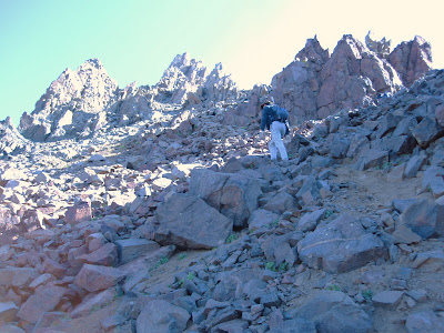 Part way up, Mark Murray, a climber we met from Colorado Springs, takes a rest.
 Mark, who has climbed about 40 of Colorado's 54 fourteeners, led most of the way. It was fun to ask him about his various climbs. He continued up the ridge.
 Mark gets closer to the notch.
 Dave and a beautiful backwards glance view of our route, so far, up the ridge.
 Mark, right before the notch. The notch is to the right of Mark. We eventually took the chute above Mark, that is visible below the summit peak. We looked to the left for an alternative route...
 and found a straight cliff.
 We climbed down into the notch, then up and into the chute that led us up to the ridge.
 At the top of the chute.
 Another view of Wright's Lake and the south side of Sneffels.
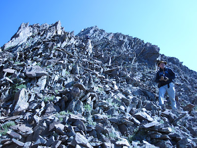
 Dave and Mark (further up) on the rock beyond the notch.
 To the east, we got a good view of the saddle on the standard route.
 Dave, very near the ridgeline, with the summit visible in the background.
 Dave, in the rocks, very near the summit.
 Going for it. I walked about 50 yards along the ridgeline and it was a thrill. Views off to my right and my left were spectacular. However, I kept my mind on the trail to avoid getting nervous about the exposure.
 Mark, at or near the summit, took our picture as we approached.
 Dave and I on the summit. What a gas! This was my favorite climbing experience ever. I've not had a lot of class 3 climbing experience and the entire southwest ridge is virtually class 3. I did not feel that there was a great amount of exposure, but there was enough to get my heart and adrenaline pumping.
 Dave and Mark on the summit.
 Some views back down the way we'd just come.
 The groomed slopes of Telluride Ski Resort are visible on the other side of the ridge to the left of center.
 Blue Lakes Basin below. Uncompahgre Peak, over 14,300 feet, is left of center on the ridge. Mark had climbed it before and it has a class 2 route to the summit (from the other side).
 From the summit, looking at the saddle on the standard route, our next destination.
 After leaving the summit, looking back up the way we'd just come. Another climber is barely visible going up the ridge to the left. He was in a group of what appeared to be six climbers. One person beat us to the top (per the summit register). The standard route is supposed to be a hard class 2, but this last portion appears to be class 3 to me.
 A closer view of the other climbers following the ridgeline to the summit, the way we'd just come.
 One more view of the other climbers.
 Our next trick was to get into the couloir that leads to the saddle. Mark went in higher than we did. He did so over some steep rock. Dave and I decided to go lower as it appeared Mark was going to have to negotiate some snow. From that vantage point, Mark took this picture of Dave looking into the couloir from below.
 Dave going down the rock, looking for a lower entrance into the couloir.
 The couloir, from where we found a lower entry point, and the saddle below.
 We climbed down the rocks below into the couloir. Dave went straight ahead into the main part of the couloir, which was a better move. I went to the right, through a narrow chute, which proved to be very steep and unstable. I ended up knocking down a bunch of loose rock on the poor people coming up from below. As a result, it was much slower going for me on the way down.
 The hiking was much better as I got into the rocks and went boulder hopping down the couloir. Even then, there was the occasional loose rock. Looking back up the couloir. The chute I came down is visible to the left (I went in just below the visible snow). The main chute is to the right.
 Looking down the couloir to the saddle. Dave is below me on the right side of the couloir.
 Looking back up the couloir from farther down. The side chute is no longer visible.
 Looking down again, Dave is now at the saddle, getting ready to go down the nasty scree.
 Another look up the couloir, this time from the saddle, on the other side of the rock mound in the middle of the saddle.
 The worst part of the hike was going down the scree from the saddle to the bottom. I'm really glad we did not go up this way. From the pictures you can get the sense that the well-worn trail up to the saddle is bereft of much loose scree. In places the scree is minimal, the ground is very hard and slippery, and once you start to slide it is hard to stop. I initially sat down on my tail and started to slide. I quickly gave up on that idea. Not only would it have worn a hole in the pants on my backside, there was no way to stop (unlike in snow where you can use an ice axe or trekking pole as a brake). I found myself avoiding bare spots and looking for the loose scree. Turning sideways, I could slide, using my trekking poles for balance and the scree helped to provide a brake to stop. Below, Dave below me. He said later he'd fallen twice on the way down, and like me, had a hard time stopping.
 Looking back up that nasty hill.
 The picture below, of the saddle on the main route, was taken from a distance earlier in the day. It evidences the well-worn trails up to and down from the saddle. Most of the people we saw going up were staying to the left side in the heavier scree outside of the well-worn area.
 Once back to the truck and on the way back out of the Yankee Boy Basin, we got a good look at Potosi Peak, the mountain we'd attempted 17 years ago.


 Someone on a quad stopped to tell us that this was the waterfall on the Coors beer can. I got a couple of pictures of waterfalls from a Coors stein...
 and the logo from Coors Light. From what I could decipher, there have been several different waterfalls over the years on the Coors logo and none appear to have been the waterfall on Sneffels Creek.
 Further down the Basin, we encountered the Ruby (I believe) Mine, now a ruin, but at one time employed about 90 people.
 A closer view of the ruins.
 Well, Sneffels has now been conquered. It was a lot of fun and whetted my appetite for some more Colorado fourteeners.
Below, a picture of Wright's Lake from the summit. The visible road is the jeep road to the trailhead. We did not make it that far, we are parked further below. The trail we were on came up the hill at the point where Wright's Lake is, went around Wright's Lake and then off to the right out of the picture.
A closer look at the spires at the beginning of the southwest ridge, up to the notch.
 On the way up to Blue Lakes Pass, looking south at Gilpin Peak. Gilpin Peak is apparently a class 2 hike following this ridge.
 Dave getting closer to Blue Lakes Pass.
 From the summit, looking down at Blue Lakes Pass. The trail we followed is visible.
 From Blue Lakes Pass, looking up the southwest ridge. We walked up just to the left of the spires and ultimately followed the ridge to the summit. I was excited and a little nervous. I've not done a lot of class 3 climbing. This was to be my first experience following a narrow ridge to a summit.
 Dave begins the hike up the rocks.
 Part way up, Mark Murray, a climber we met from Colorado Springs, takes a rest.
 Mark, who has climbed about 40 of Colorado's 54 fourteeners, led most of the way. It was fun to ask him about his various climbs. He continued up the ridge.
 Mark gets closer to the notch.
 Dave and a beautiful backwards glance view of our route, so far, up the ridge.
 Mark, right before the notch. The notch is to the right of Mark. We eventually took the chute above Mark, that is visible below the summit peak. We looked to the left for an alternative route...
 and found a straight cliff.
 We climbed down into the notch, then up and into the chute that led us up to the ridge.
 At the top of the chute.
 Another view of Wright's Lake and the south side of Sneffels.
 Dave and Mark (further up) on the rock beyond the notch.
 To the east, we got a good view of the saddle on the standard route.
 Dave, very near the ridgeline, with the summit visible in the background.
 Dave, in the rocks, very near the summit.
 Going for it. I walked about 50 yards along the ridgeline and it was a thrill. Views off to my right and my left were spectacular. However, I kept my mind on the trail to avoid getting nervous about the exposure.
 Mark, at or near the summit, took our picture as we approached.
 Dave and I on the summit. What a gas! This was my favorite climbing experience ever. I've not had a lot of class 3 climbing experience and the entire southwest ridge is virtually class 3. I did not feel that there was a great amount of exposure, but there was enough to get my heart and adrenaline pumping.
 Dave and Mark on the summit.
 Some views back down the way we'd just come.
 The groomed slopes of Telluride Ski Resort are visible on the other side of the ridge to the left of center.
 Blue Lakes Basin below. Uncompahgre Peak, over 14,300 feet, is left of center on the ridge. Mark had climbed it before and it has a class 2 route to the summit (from the other side).
 From the summit, looking at the saddle on the standard route, our next destination.
  After leaving the summit, looking back up the way we'd just come. Another climber is barely visible going up the ridge to the left. He was in a group of what appeared to be six climbers. One person beat us to the top (per the summit register). The standard route is supposed to be a hard class 2, but this last portion appears to be class 3 to me.
 A closer view of the other climbers following the ridgeline to the summit, the way we'd just come.
 One more view of the other climbers.
 Our next trick was to get into the couloir that leads to the saddle. Mark went in higher than we did. He did so over some steep rock. Dave and I decided to go lower as it appeared Mark was going to have to negotiate some snow. From that vantage point, Mark took this picture of Dave looking into the couloir from below.
 Dave going down the rock, looking for a lower entrance into the couloir.
 The couloir, from where we found a lower entry point, and the saddle below.
 We climbed down the rocks below into the couloir. Dave went straight ahead into the main part of the couloir, which was a better move. I went to the right, through a narrow chute, which proved to be very steep and unstable. I ended up knocking down a bunch of loose rock on the poor people coming up from below. As a result, it was much slower going for me on the way down.
 The hiking was much better as I got into the rocks and went boulder hopping down the couloir. Even then, there was the occasional loose rock. Looking back up the couloir. The chute I came down is visible to the left (I went in just below the visible snow). The main chute is to the right.
 Looking down the couloir to the saddle. Dave is below me on the right side of the couloir.
 Looking back up the couloir from farther down. The side chute is no longer visible.
 Looking down again, Dave is now at the saddle, getting ready to go down the nasty scree.
 Another look up the couloir, this time from the saddle, on the other side of the rock mound in the middle of the saddle.
 The worst part of the hike was going down the scree from the saddle to the bottom. I'm really glad we did not go up this way. From the pictures you can get the sense that the well-worn trail up to the saddle is bereft of much loose scree. In places the scree is minimal, the ground is very hard and slippery, and once you start to slide it is hard to stop. I initially sat down on my tail and started to slide. I quickly gave up on that idea. Not only would it have worn a hole in the pants on my backside, there was no way to stop (unlike in snow where you can use an ice axe or trekking pole as a brake). I found myself avoiding bare spots and looking for the loose scree. Turning sideways, I could slide, using my trekking poles for balance and the scree helped to provide a brake to stop. Below, Dave below me. He said later he'd fallen twice on the way down, and like me, had a hard time stopping.
 Looking back up that nasty hill.
 The picture below, of the saddle on the main route, was taken from a distance earlier in the day. It evidences the well-worn trails up to and down from the saddle. Most of the people we saw going up were staying to the left side in the heavier scree outside of the well-worn area.
 Once back to the truck and on the way back out of the Yankee Boy Basin, we got a good look at Potosi Peak, the mountain we'd attempted 17 years ago.
We stopped to take a photo of a waterfall, with Sneffels in the background.
I have virtually the same photo from our trip 17 years ago, but then Sneffels was blanketed in white and we'd not been to the top of it.
Someone on a quad stopped to tell us that this was the waterfall on the Coors beer can. I got a couple of pictures of waterfalls from a Coors stein...  and the logo from Coors Light. From what I could decipher, there have been several different waterfalls over the years on the Coors logo and none appear to have been the waterfall on Sneffels Creek.
 Further down the Basin, we encountered the Ruby (I believe) Mine, now a ruin, but at one time employed about 90 people.
 A closer view of the ruins.
 Well, Sneffels has now been conquered. It was a lot of fun and whetted my appetite for some more Colorado fourteeners.