Mount Nebo, located northeast of Nephi, Utah, is an impressive mountain with three distinct peaks. This is as scene from the west side

and this is as seen from the east side.

The northern peak, at 11,928 feet, is the tallest point in the Wasatch Range and in Utah County.

The southern peak, at 11,877 feet, was thought for many years to be the high peak. I hiked to the south peak (the pointed peak, below, in the upper left) on August 1, 1992 with my brother-in-law, Dave Kenison.

It was a 16 mile roundtrip with over 5,400 feet of elevation gain (the trailhead is at 6,450 feet). Just recently, on August 14, 2010, over 18 years later, I did the north peak with Dave Kenison, my son, Sam, and his friend, Mike. It was a 9 mile roundtrip with about 2,700 feet of elevation gain (the trailhead is at 9,200 feet). They were very different hikes.
The hike to south peak is straight forward, long and hot and there is no water along the way. The hike initially starts on a trail that goes to Andrews Ridge. Below, as seen from near the summit of the south peak, Andrews Ridge is covered with trees and goes down to the left.

It then climbs about 3,000 feet up Andrews Ridge

until it meets the main Nebo Ridge at about 10,200 feet.

There are some steep climbs, often with little in the way of switchbacks, but very little exposure. The last 577 feet to the summit, after a beautiful alpine meadow at 11,300 feet,

is very steep and grueling, but otherwise unspectacular.

There were some flowers that managed to grow at the higher elevations

among the shale.

Lower, we saw a grouse

and some beautiful wildflowers, such as columbine,

and lupine,

primrose,

Indian paintbrush,

and what must be some kind of aster,

(me, sitting in the alpine meadow)

but the reward was at the summit, where the knife edge ridge that connects the south peak to the middle peak and the middle peak to the north peak is truly spectacular.

I walked part way down the knife edge ridge toward the middle peak until I had enough and turned back. The views down both the west and east sides were also spectacular.

We did the hike in just over 8 hours (we left at 6:40 a.m. and were back by 2:50 p.m.).
The hike to the north peak is very different. It is much shorter and there is much less elevation gain, so it is an easier hike. However, its steeps are steeper, it has much more exposure and there are significant amounts of loose shale that make the exposure more intimidating. There are also some relatively significant downs, that have to be made up, that make the overall elevation gain more in the neighborhood of 3,400 to 3,800 feet. The views are more varied and more interesting and the trail, particularly after reaching the 11,460 foot sub-peak, is much less obvious. The trail starts at about 9,200 feet along the north side of Hell Hole, first up, then down, then up again, to the north of North Peak, the tallest peak in the middle below.

There it turns steeply southwest up to a ridge

and traverses the west side of North Peak,

offering spectacular views of the north peak of Mount Nebo.

The trail then drops several hundred feet to grassy Wolf Pass at 10,600 feet.

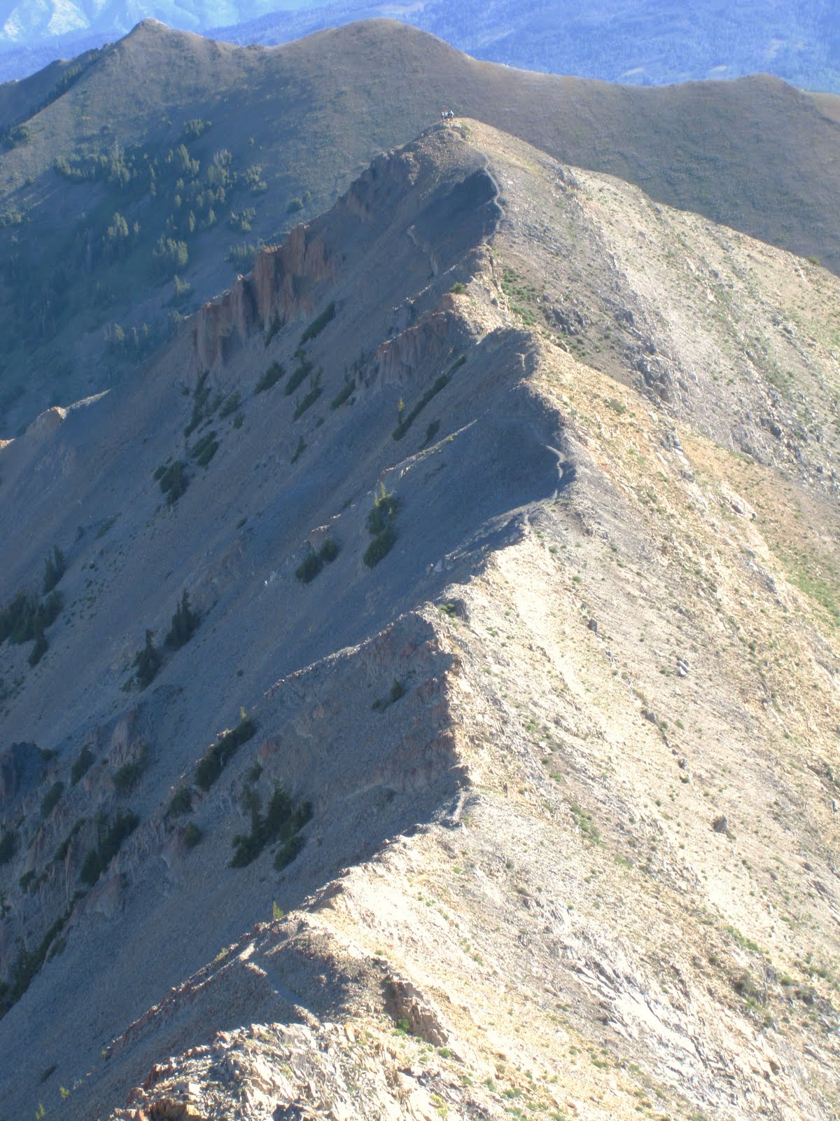
From there the trail heads very steeply south up the ridge, below, looking back toward Wolf Pass,

eventually breaking free of vegetation and reaching the 11,460 foot sub-peak. The sub-peak below, with people on top, as seen from below the north peak of Nebo. The trail is visible along the ridge.
Right before the sub-peak, you catch a view of the north peak which is awe-inspiring and a little scary. It was hard to see a route up to the summit.

From the sub-peak to the north peak, the trail, through mostly loose shale, follows the nearly knife edge ridge.

Nearing the north peak summit, we veered to the left up some loose shale that was not quite as steep and looked easier to negotiate with less exposure.

The shale was a little looser and we were more careful

as we traveled around the east side

and then up to the summit.

Dave decided he wanted to hike to the middle peak. The middle peak is to the right and the south peak is in the left center below.

After a steep hike down the south side of the north peak, and startling some bighorn sheep, 

he made it to the middle peak, below. Others can also be seen on the south peak.

Sam and I on the summit of the north peak.

and a view from the top toward Mona.

On the way back, a backward glance at the north summit which looked different in full light.

We did the hike up in about 3 1/2 hours and the hike back down in 2 1/2 hours.
Beautiful pictures, but I was startled to see pictures slipped in of you two old white-heads prior to your graying days. And Bob, I swear you still have that same t-shirt.
ReplyDeleteIn t-shirts, like women, if I have a good thing, I keep it around.
ReplyDeleteAhhh....
ReplyDeleteWow, when I saw those two years old pictures, I thought, "My goodness, hiking sure agrees with those guys. Makes em look years younger." Well, I hope you feel young as ever, doing those hikes. This non hiker appreciates the photos and the descriptions.
ReplyDeleteGreat blog post. My Mom and I hiked almost to the north point yesterday but we were racing the clock and had to turn around.
ReplyDelete