When you are in Victoria Falls, Zimbabwe, you focus on Victoria Falls and the Zambezi River which feeds it. Victoria Falls is one of the
seven wonders of the natural world.
We had two activities on the
Zambezi River. The Zambezi is the fourth longest river in Africa after the Nile, Congo and Niger Rivers. Its source is in northwestern Zambia and it flows 1,678 miles through six countries to Mozambique where it empties into the Indian Ocean.
We took a guided canoe trip on the Upper Zambezi (above the Falls) where the Zambezi is very wide and slow moving. We drove west of Victoria Falls on the Zimbabwe side through Zambezi National Park and put in our canoes up river and then spent the next several hours canoeing east down the Zambezi.
 |
| Our inflatable canoes on the truck. |
 |
| Our drop-in point. Hippos were out in the river beyond the first island to the left. Our guides kept us a long distance from any hippos they spotted and they knew the spots where they like to congregate. |
We were with a father and his 13 year old son from Colorado (in one canoe), a young engaged couple from Japan (in another canoe) and two guides (who shared a canoe). Judy and I also shared a canoe.
 |
| Father and son with an island beyond them. |
 |
| Judy in the front of the canoe. |
We had hippos bellowing in the river not too far from where we put in and saw several more hippos on the way down. We saw one crocodile and some bee-eaters, but I was a little disappointed we did not see more wildlife.
We did hit some mild class 1 and class 2 rapids which added a little excitement and got us a little wet.
 |
| We didn't actually get photos of the rapids. The guides collected all of our valuables, such as wallets and cameras and put them in a dry-bag before that section. We did get quite wet through the larger rapids. |
The most impressive thing was watching the mist from the falls rising in the air like smoke from a fire. The local name for Victoria Falls is "Mosi-oa-Tunya" which means "smoke that thunders."
 |
| Our guides in their canoe and the mist of the Falls in the distance. |
 |
| The father and son duo do some synchronized rowing with the Falls as a backdrop. |
At the end when we pulled out we had a wonderful lunch, including crocodile kabobs which I really enjoyed, the best crocodile we ate in Africa (and we had it quite a few times).
 |
| Our pull-out point. |
 |
| Wonderful crocodile kabobs. |
That evening we took a Sundowners Cruise on the Upper Zambezi not too far above the falls on a large boat where each table on the lower and upper deck had a river view. They served drinks and some appetizers.
 |
| Watching the sunset from our boat in the Zambezi. |
 |
| The sun going down. |
 |
| Another one of many boats like us on the Zambezi for a sundowner. |
We did see some fun wildlife, including quite a few hippos, a clay river bank full of nesting bee-eaters and some fun birds, including spur-winged geese and yellow-billed storks.
 |
| Bee-eaters. |
 |
| Yellow-billed stork. |
The river is the border between Zimbabwe and Zambia and our first night we took a series of tax cabs back and forth from Zimbabwe to Zambia to eat at the Royal Livingstone Hotel on the Zambia side so that I could put a check-mark on visiting Zambia. From the Royal Livingstone we could see the mist of the Falls fairly closely. On our Sundowners Cruise we also cruised on the Zambia side of the Zambezi.
 |
| The mist of the Falls from the Royal Livingstone. |
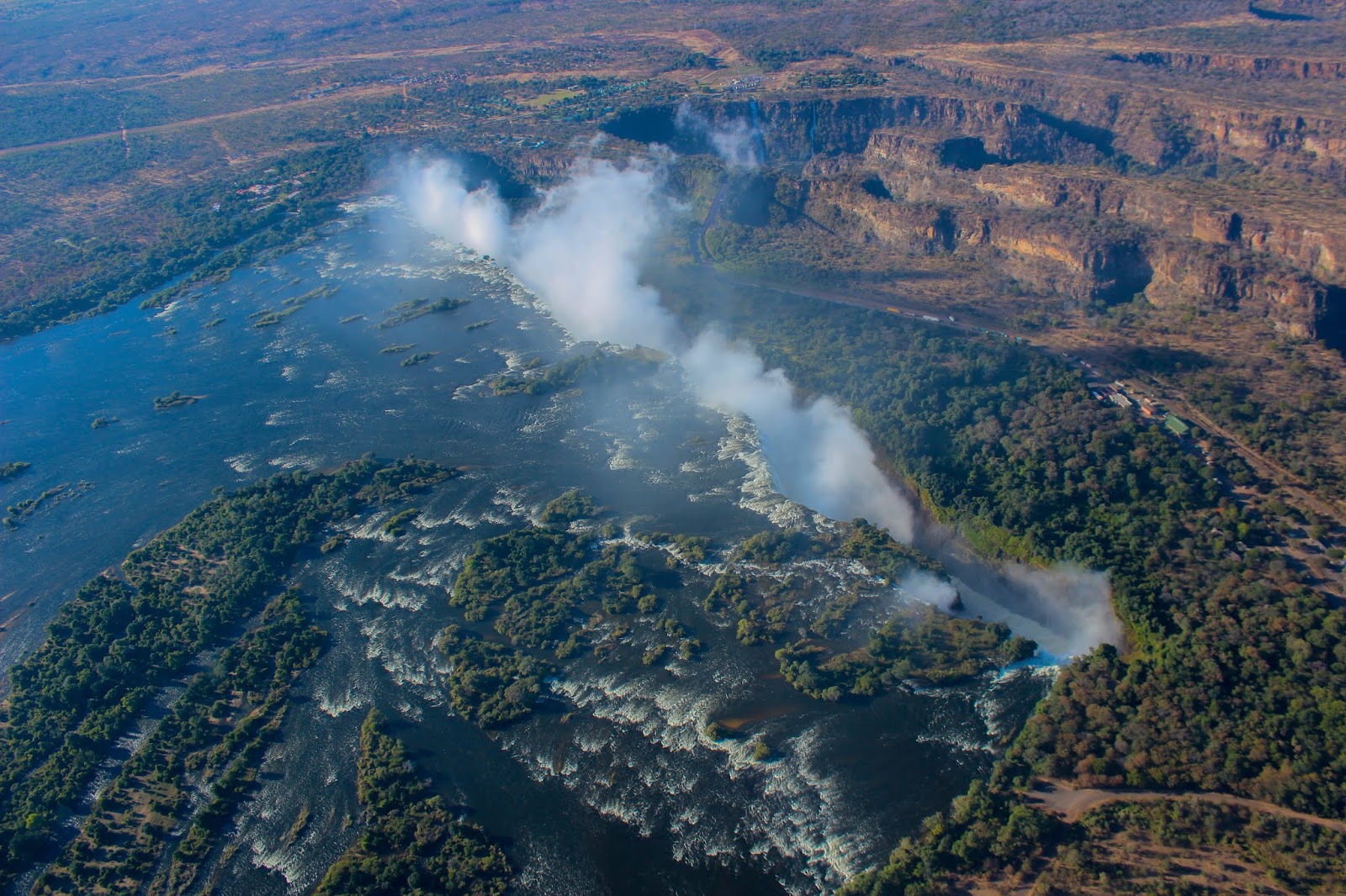
Our familiarity with the Zambezi and the Falls increased dramatically the next morning when we took a 26 minute helicopter flight over the Falls and both the Lower and Upper Zambezi with Zambezi Helicopters.
 |
| We were the first flight in the morning. Here the helicopter is just getting ready for us to board. |
 |
| One of our first views of the Falls from the helicopter, right after lift-off. |
 |
| Judy smiles from the front seat. |
Part of the flight was okay for pictures, but part was horrible as the morning sun was directly in our face. We circled around the Falls twice and could clearly see that the Falls drop over a knife-edged cliff into a narrow T-shaped chasm. The Falls empty into the cross-bar of the "T" which is 1,859 yards long, then drain out the support post of the "T" past the Victoria Falls Bridge and into a series of steep, narrow goose-necked canyons.
 |
| The "T" of the chasm is clearly visible. Toward the bottom, left of center, the Victoria Falls Bridge which is just below where the supporting bar of the "T" leaves the cross-bar of the "T" from the chasm. The Upper Zambezi is seen for miles and opens up broadly right before the Falls. |
 |
| The falls and mist at the intersection of the "T." |
 |
| The bridge visible from the other side of the Falls. |
 |
| The size of the chasm is amazing. |
 |
| The cross-bar of the "T." There is so much mist you can't even see the connecting point of the "T." |
These narrow canyons are the beginning of the Middle Zambezi where commercial white-water rafting takes place on a class 5 section of the Zambezi (the highest rapid rating for river-rafting). The Zambezi was at a 9 year high while we were there and no river-rafting was allowed at that time on the Middle Zambezi because it was too dangerous. It is that high flow rate which causes so much mist to rise from the Falls.
 |
| The beginning of the goose-neck canyons can be seen below the Falls. |
 |
| From a greater distance, more of the goose-necks are visible and white-water in the canyon is visible below. The spray from the Falls is visible for miles. |
 |
| The view of the goose-necks is seen here from the other side of the Falls. |
The last part of our helicopter ride took us a few minutes over Zambezi National Park where we saw some wildlife, including impala, zebras, elephants and giraffes - particularly giraffes as they are so much easier to spot from the air.
 |
| Giraffes from the air. |
 |
| Zoomed in on a giraffe. |
After our helicopter ride we were transported to the Falls and took a walking tour of the Falls. It may have been the most spectacular of our activities, even more so than the helicopter.
As indicated, the Falls are flowing very strong right now and they cause there own weather (rain and wind). We each had water-proof jackets, added rubber ponchos and also brought along umbrellas to help with picture taking. We highly recommend all of the same for anyone else doing it. We saw lots of people who looked like swamp rats with cameras that looked like they'd been through a washing machine.
 |
| The only time we dropped our poncho hoods - while our guide took our picture. You can see the sun shining, but it is raining hard. |
They claim that Victoria Falls is the largest waterfall in the world. There are different ways of measuring waterfalls, but two of the other impressive falls used for comparison are Niagara and Iguazu. Victoria is 360 feet tall, while Niagara is 167 and Iguazu is 210 to 269. Victoria is 1,859 yards long (1.06 miles) and split into five different falls (one long sheet of water when it gets really large). Iguazu is 1.7 miles long, but about 983 yards of it (.56 miles) has no water flow over it (it is split into about 275 different falls and large islands). The average annual flow rate of Victoria is 38,420 cubic feet/second. It is 85,000 for Niagara and 61,660 for Iguazu. However, Victoria's flow rate is dampened dramatically during the dry season. When you look at maximum recorded flow, Victoria is 250,000 cubic feet/second, Niagara is 293,000 and Iguazu is an amazing 1,614,000.
From the Zimbabwe side, the first of the five falls is the Devil's Cataract. We got a direct side view there that was amazing. We could see the water rushing down to our left and lots and lots of mist ahead. We couldn't really see the river below, it was just too frothy and had too much mist. This was my favorite part.
 |
| A look into the cross-bar of the "T." Devil's Cataract is flowing in from the left. |
 |
| Devil's Cataract from above. |
 |
| From even a little higher. |
 |
| Across from Devil's Cataract. |
 |
| Looking back at Devil's Cataract. |
The Main Falls is the largest of the five and strong winds caused by the falling water turn much of it into mist.
 |
| The Main Falls. |
 |
| About this time on pictures became mostly futile. Wind was strong, rain was blowing sideways, and all you could see was mist. |
Horseshoe Falls is shaped like a horseshoe and has the least volume of water. It is the first one to dry up, usually in October or November.
 |
| I believe this is part of Horseshoe Falls. |
Rainbow Falls is the highest point and a rainbow can usually be seen there. I didn't even attempt a look there. It was just mist, sideways blowing rain and wind.
The Eastern Cataract is on the Zambia side and are the second highest of the five falls. They can be viewed from Danger Point. At that point, I let Judy and the guide go to danger point. I had no desire to as the wind and the rain was so strong you couldn't see anything. Judy took the buffeting and beating and loved it. People think of me being a little crazy, but don't realize that Judy's got a good dose of that herself. That is where the support of the "T" breaks through the chasm. A short little walk to the east and you can see the Victoria Falls Bridge which we crossed by cab to get into Zambia.
 |
| The bridge and a rainbow below it. People bungee jump from the bridge, among other activities. |


What? Me crazy? I loved our walking tour of the falls. One of the highlights of the trip for me. So much power!
ReplyDelete