My previous post was on our hike up Mount Harvard, one of the fourteeners in the Collegiate Peaks Wilderness of the Sawatch Range in Colorado. This post continues from that same day, when we hiked from Mount Harvard to Mount Columbia and then out, down the west slope of Mount Columbia, to the North Cottonwood Creek Trailhead where we started. We were hiking on very little sleep and as we left the summit of Harvard, we were facing an intimidating 2.75 mile traverse along and below a nasty looking ridge to Columbia.
The route description warns that "You'll need at least a couple of hours to get to Mt. Columbia so don't start the traverse if the weather is deteriorating." Thunderstorms were predicted later in the day and several other people on the summit decided not to take the Columbia route because of that threat. I must admit to some trepidation as we started out, with good cause. However, I must admit to taking comfort being with Sam, who in the past year has developed a fitness and expertise in the mountains that I find amazing. The two hour prediction is for mountain goats, army rangers and perhaps Sam. For me (and Sam because he was with me), it was between four and five hours along jarring terrain that was energy sapping and with no easy way out. We started out along the rocky ridge of Mount Harvard,
sometimes with a trail and sometimes without, starting to lose some significant elevation.
We had some urgency because of the predicted thunderstorms. Not too long after we started the serenity of the wilderness was pierced by man-made buzz of a helicopter that we could hear beneath us.
It is very strange to hear a helicopter coming from underneath and to be looking down on it as it ascends and crosses a ridge lower than you. After dropping several hundred feet we found a flat area.
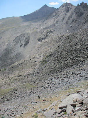
It was a proverbial calm spot before some hiking hell. We started rock hopping around the north side of a ridge, not quite sure whether to drop down or stay high. Sam, who is comfortable on class 3 to class 5 rock, was inclined to stay high. At one point I went low and he stayed high and he eventually called me to come up, saying there was a trail. Below, Sam staring into the abyss.
The route guide noted "a loose gully" which was more direct, the trail Sam was looking at, but that it was "an ugly descent on very loose rock." The route description showed a route dropping way down far to our left, out of the picture, then talus and boulder hopping back up to go up and around the large boulder nob in the upper left center of the picture at the base of the ridge. The route then stayed along the base and curved around the last significant peak before the Columbia massif itself, and regaining the ridge for the slog up to Columbia. I was going to go low and Sam decided to stay with me, noting that the last time he'd split up with a hiking companion, it had resulted in a search and rescue effort in a storm, something that we were potentially facing. We started down some steep, sometimes loose, boulders and scree, trying to find the easiest way to avoid the nastiness we were facing.
I loved the color contrast of the lichens here.
We didn't want to drop too low, because we knew we had to make it up again. On the other hand, I didn't want to stay too high and face some apparent class 3 or 4 rock. Sam decided to stay to the right of the first large outcropping directly in front of him.
I decided to go lower and pass to the left of it and and up the next gully and then up to the right of the middle large nob of rocks.
This part of the trip was energy sapping. The boulders were large and had to be negotiated carefully as big gaps between them had drops of 10 or 15 feet that could have resulted in injury if we'd fallen. There were frequent leaps between boulders, or climbing up and around or over them. We ended up dropping over 1,600 feet from the summit of Harvard, to below 12,800 feet. From there, each foot gained, to reach 14,000+ feet on Columbia was an effort. As Sam went high, encountering some class 3 rock, I stayed low. I noticed several mountain goats in the vicinity of where Sam was.
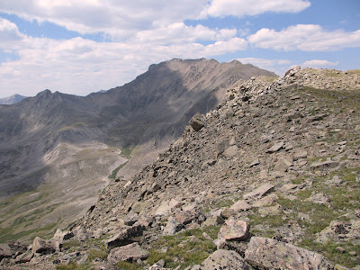
He got a much closer look at them, but was relieving himself and unable to get a good picture. I eventually hit some smaller and looser scree and then a little easier hiking with some dirt between the rocks. I didn't see Sam for sometime as he negotiated his higher route. Looking back at the summit ridge of Harvard and the rugged terrain we'd traversed to that point.
We went down the long ridge going left to lower right and went down the ridge into the gully in the area of light dirt patches toward the bottom right.
Eventually, the summit of Columbia came into view and what looked like more difficult boulder hopping.
I eventually spotted Sam, looking for me much farther back. I'd made better time than he anticipated. We met and made it back to the ridge with a wonderful view of Harvard.
From that ridge, the top of Columbia was looking doable.
Although it looked tough, after what we'd been through, this ridge run was relatively easy. It went much faster than I anticipated. We made good time and I thought I saw Sam at the summit,
only to find that the summit was still a little further ahead. Sam got a nice shot of me hiking up toward the summit with Harvard and the traverse in the background.
Finally, we made the summit of Mount Columbia, at 14,073 feet, a nice feeling of accomplishment shared with Sam.
Another summit view looking toward our descent route down the west ridge of Columbia.
Another view with Mount Yale in the distance.
We shared the summit with several other hikers who'd come in from an infrequently used route from the southeast ridge and with a marmot, god of the summit, that was seeking trail mix sacrifices from those of us who had entered his temple sanctuary.
At this point, I was ready to be done, but we still had 5.75 miles to go to get out. Fortunately, no thunder showers, and we wanted to get down before any came. As we left, a look back at the other hikers on the summit with Harvard in the background.
I really loved Harvard. Columbia, not so much. As we started down, we encountered another god (marmot) watching over his kingdom.
He didn't seem too concerned by us, and was not seeking oblations. So we continued on. We looked back to see Harvard to our left and Columbia to our right, about to fade from our sight as we headed down for another hell hole, this time of loose scree.
The route description sums it up pretty well: "the trail is steep, loose and not so fun...the upper end of the gully is steep, loose and ugly." This part of the trudge was tough on the toes, slamming into the ends of the tennis shoes, and on the knees, straining to avoid a hurtling talus slide to the bottom. We encountered another god, this time a pretty pika.
He could have this kingdom. We couldn't get out fast enough. I didn't take many pictures, it was too sadistic and ugly. At one point I'd had enough and sat on my tail and slid down. That was only a short distance before I wore a hole in the back of my trousers and had to pick stickers out of my rear end. Finally, toward the bottom I turned around and took a photo of what we'd just come down.
We came through the middle of the gully in the center and then around to the right above the prominance. This photo gives no justice to the steepness, looseness and meanness of what we'd come down. We eventually lost the trail, just before we hit the trees, and followed our ugly route down with a trailess trudge through downed trees and mushroom rich bogs hoping to run into the trail. We eventually did, but not until we'd expended significant time and effort. We were finally on the same trail we'd taken in early that same morning. It seemed like several days ago. What had been a beautiful trail on the way in, was now a long slow and never-ending trudge out. We kept thinking we were getting close, to have our expectations dashed. Many miles on little sleep will do that to you, especially after miles of boulder hopping, talus slipping and sliding, and hiking through downed timber and bogs. After what seemed like an eternity (maybe I should have sacrificed to the gods above), we hit the trailhead and the car about 7:00 p.m., 15 miles, over 6,100 feet of elevation gain and 13 1/2 hours from when we started. I really liked Harvard, I really disliked the route to and off of Columbia. Despite my grumbling, all in all, it was a great and challenging day of hiking. The weather, although threatening some ugliness, came through for us. This hike, partly due to the challenge, was by itself, worth the trip to Colorado. Fortunately, we had some more in store.


Heaven and Hell in a single post. Love the pictures of you and Sam. I used to tell you to make sure you take good care of the boys on these kinds of hikes, but now I it is nice that he is there to take care of you.
ReplyDeleteI'm just wondering: "hiking hell"-is that a technical term?
ReplyDeleteThese pictures show views that are definitely less appealing than your previous day.
Yes, h - e - double toothpick, as distinguished from h - ev - uhn, generally denoting conditions like steep hills with no footing and lots of loose gravel that pin your toes against the fronts of your shoes and large boulders, never ending, that sap your energy and you still don't get anywhere.
Delete