Saturday, May 9, 2009

Peking Duck: Lotus Garden

One of my favorite foods is Peking duck. I've had it several times at a very nice restaurant in Beverly Hills (when attending the USC Tax Institute with John Mirau), in Monterey Park (with Wing Lau and Eddie Ngo and our wives), in Beijing, China (with Judy, Rachael and Nate, where it originated), and finally, many times with Wing Lau at Lotus Garden in San Bernardino. The Peking duck at Lotus Garden is as good or better than that I've have had at the other places. I decided I wanted to try and make Peking duck for Judy this Mother's Day. In anticipation and preparation for that, I went to Lotus Garden with Wing Lau and had the Peking duck with the intention of paying attention to how they presented it and for a comparison. The duck is brought to a small portable table near our booth.

A chef begins to carve the bird, cutting off the legs and wings which are put on one separate plate, and carving off breast and other meat which is put on another plate.

The legs and wings are on one plate are for us to pick up and eat as they are. We generally pick them up by the bone and eat them by hand, perhaps adding a little hoisin sauce. I don't believe any of the other restaurants I've been to do it this way.


The other plate, with the carved breast and other body meat, is used to make the little crepes or burritos (I'm not sure what they are called) with the addition of Chinese pancake, hoisin sauce and scallions. The restaurant we went to in Monterey Park separated the duck skin from the duck meat and served it separately. I like it better with the skin connected to the meat.

The chef adds some hoison sauce to the Chinese pancake, then puts on slices of scallion.

Then, slices of duck meat, including skin, are added on top.

My pictures of the finished product did not turn out, but as always, it was wonderful. We were then offered the balance of the carcass to take home, which I did. It can be used to make soup, or just to heat up and pick off the remaining meat.

Well, we'll see how my version turns out. I hope it is edible.

Grilled Kobe Style Beef

While visiting a Japanese market in Los Angeles I found some American Kobe Style Beef and decided I needed to try it. I have previously eaten Kobe beef sashimi at Kaikaya-By-The-Sea, an incredible restaurant in Tokyo, but never cooked.
In Japan, Kobe beef is beef from the Tajima cattle, a species of Wagyu cattle, born, fed and slaughtered in Hyogo Prefecture, with a marbling ratio of 6 or above, a meat quality score of A or B and gross weight of the beef of 470 kg or less. The cattle are fed a beer a day, are massaged daily with sake and are slaughtered in a humane, painless way.

With the increase in popularity of Kobe beef in the United States, Kobe style beef was developed here. Domestically raised Wagyu beef were crossbred with Angus cattle to provide a meat that is less-white, more in keeping with American tastes. The cattle are fed a mixture of corn, alfalfa, barley and wheat straw and it is unclear to me whether they are also fed beer and massaged with sake. The American version is called American Kobe Style Beef, which is what I purchased.

Note that the marbling is incredible, much more than you would find in a typical rib-eye.

In grilling the Wagyu beef, a weird looking blotchy pattern emerged.

I was a little disappointed to find that I could not really distinguish the taste of this from a regular rib-eye steak. I would like to try it again with a larger cut of meat.

In fact, I cooked a buffalo New York cut steak at the same time (a later post) and found that I preferred its taste.

Wednesday, May 6, 2009

PCT: San Felipe Hills to Warner Springs

Rick DeLong and I met at 5:45 a.m. on May 1st at Scissors Crossing, on the south side where the S2 meets Hwy 78 in the San Felipe Valley. After a short walk, we crossed Hwy 78 and began a gradual ascent of Grapevine Mountain. We soon entered Anza-Borrego Desert State Park and the first few miles were some of my favorite of the trip. We were at a lower elevation, starting at 2,254 feet, and the landscape was dominated by hedgehog cactus and agave. Below, some hedgehog cactus are sharing some rocks with some non-blooming agave.
Much of the hedgehog cactus was in bloom. There were also quite a few barrel cactus which were just beginning to bloom.
Below are some of the best blooms we saw on a barrel cactus. Most of the flowers had not yet opened up.
The hedgehog flowers can be purple or red, but most of what we saw were purple.

Agave were everywhere, in varying stages of development. Many dead agave stocks were still standing or lying on their sides. Others were shooting up, without branching out, and a few, like those below, were almost ready to bloom. We did not see any in full bloom. Agave is used in Mexico to make Tequila. There was enough agave here to start a distillery.

Below, looking out across the San Felipe Valley to the Cuyamaca Mountains.


Looking a little more north, the town of Julian is nestled in the mountains, just a little right of the middle. Rick, who is thru-hiking the PCT, had hitch-hiked in to Julian to resupply before I met him.
Rick, shading himeslf with his distinctive umbrella, waits patiently for me while I take pictures of blooming cactus.
A grouping of beaver-tail cactus with a back-drop of cholla.

Some of the cholla was just beginning to bloom.

The beaver-tail cactus were also pretty far along in their bloom.

Below, looking east into Grapevine Canyon and the Grapevine Hills.

An area dominated by cholla.

Many yucca were also in bloom.

As we continued on, we increased in elevation. The floor of the San Felipe Valley got farther away and the Volcan Mountains rose up on the other side of the valley, eventually reaching over 5,000 feet and containing pine trees. The Volcan Mountains suck up most of the moisture of passing clouds and create a rainshadow for the San Felipe Hills.

After almost 12.8 miles, we reached an area where "trail angels" had deposited gallon jugs of water. It was nearing 90 degrees and I'd drunk over 4 liters of water. I happily filled up with the donated water. In this vicinity, we saw at least four coast horned lizards. I saw a quick moving snake I could not identify and several other hikers mentioned seeing rattlesnakes along the trail.

At this point, we'd climbed almost 1,400 feet to a ridge crest of 3,600 feet, and then dropped down to the water at 3,485 feet. We began a slow climb of very long switchbacks, climbing another 900 feet to a ridge at 4,395 feet, and saw the Montezuma Valley in the distance and San Ysidro Mountain beyond it.

We camped Friday evening about 7:30 p.m., after going about 20.4 miles. Saturday morning, May 2nd, we headed lower toward the Montezuma Valley. We began to get a different kind of vegetation, including many beautiful flowers.

A closeup of the unidentified flower.

The Montezuma Valley, looms below, full of trees.
After 3.5 miles, we reached Barrel Spring, about 75 yards south of S22, Montezuma Valley Road. Barrel Spring has a pipe going into the ground to access the spring water, with a pipe draining the water into a cement catch-basin. A sign said the spring was mouse contaminated. The spring looked closed-over to me and I drank and filled up without treating the water (four days later, I'm not feeling any ill effects).

At Barrel Spring, we were entertained by the antics of some acorn woodpeckers.

The trail crossed S22 and entered into a completely different kind of terrain. There were small hills with scrub oak with valleys of dry grass.

Eventually we entered into some wide open areas of grassland, with some wildflowers interspersed among the grass.

A closeup of the beautiful yellow flowers in the grasslands.

We eventually entered into a more hilly area and found beautiful San Ysidro Creek, a spot that would make a very nice camp, shaded by a white sycamore.

We switchbacked up a ridge, through more scrub oak, and then entered into another wide expanse of open grassland. We encountered a beautiful area with wild California poppies.


Then a few miles from Hwy 79 on the outskirts of Warner Springs, we encountered what for me was a complete surprise, beautiful Canada Verde (Green Ravine), with a small stream running through it and protected by huge oak trees and full of luscious, green grass.

We picked a spot under a large oak tree and ate a late lunch, stretched out in the tall grass. After reaching Hwy 79 near the U.S. Forest Service Fire Station in Warner Springs, we continued on another 1.8 miles to my car located on Hwy 79 on the other side of Warner Springs. The 1.8 miles were pretty unexciting, most of it through a large cow and horse pasture, with some glimpses of Lake Henshaw in the distance. We did 14 miles on Saturday, for a two day total of 34.4 miles. It was a hike with some quite varied terrain and worthy of the PCT label that adorns it.

Tuesday, May 5, 2009

Coast Horned Lizard

When I was four, my family moved into a new house in the Avenues of Salt Lake City, on the edge of City Creek Canyon. The foundation for a new home was being excavated a short distance from ours and my friend, Mark Molen, and I were playing at the site. We discovered an amazing creature that I was sure was a baby dinosaur (an ankylosaurus). It had spikes all over its back.
We caught it and excitedly showed my mother our amazing discovery. She shared our excitement and said nothing to persuade us that it was not a prehistoric creature. Soon we were playing in the sandbox in my backyard and placed the baby dinosaur on the teeter-totter. When we finished playing, I was devastated to find that the baby dinosaur was gone! This was my first encounter with a horned lizard, or as I came to know them later growing up, a horny toad.
Horny toads get their name from their rounded shape and blunt head, a shape much like a toad. The scientific name, phrynosoma, means toad body (phrynos means toad and soma means body), although it is actually a lizard, not a toad. Until yesterday, I'd never heard the term "horny frog," or "horned frog" in relation to a horned lizard. However, I learned that the horned frog, the mascot of Texas Christian University, is a reference to the Texas horned lizard. Below is a sculpture of the mascot on the TCU campus:

On a recent backpacking trip along the PCT in the San Felipe Hills, we came across a large horned lizard. It ran a short distance and then stopped, motionless. It did not move while we took pictures, quite close up. They blend into their background in an amazing way. This is one of their defense mechanisms.

Within a short distance, perhaps 100 yards, we saw another two horned lizards under the same tree. One was gray, like the first one, above. However, the other was a beautiful brown and orange. I thought it was a completely different sub-species. Note that, it too, blended perfectly with its background.

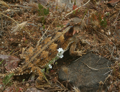
When I got home and looked at my pictures and a guidebook, I was quite shocked to find they were the same species, the coast horned lizard. I learned that they can change colors to blend in with their background, like a chamelion, but I found nothing that indicated how quickly this can happen, or how much the color pattern can vary in a short time. In about another quarter mile, I found another brownish horned lizard, with less orange. It also blended into its surroundings very well.

I particularly liked the brownish orange horned lizard we saw. Even the horns on its head had color variation, some orange, some black and some brown.


A closeup of the head of the first, gray horned lizard, reveals that its horns are primarily gray, but it, too, had some partially black horns.

Since my youth, when I found lots of "horny toads" in the hills near my home, I've only seen them a few times, and then, only in remote locations. It has seemed to me that they must be in decline. One was found along the PCT near Deep Creek, between Lake Arrowhead and Mojave River Forks Dam.

On two separate occasions, I've seen them along the PCT in the Mission Creek area, between Mission Creek Canyon and Whitewater Canyon, near Fork Springs. Note, again, the amazing blending of the horned lizard with its background.

It was there they I encountered one of the other horned lizard defense mechanisms: they can shoot blood from the corner of their eyes. I was trying to catch the horned lizard when the liquid shot out. At the time I was startled, not quite sure what I'd seen. It missed me and I did not realize it was blood. Again, it was later, in reading a guidebook that I discovered this as a defense mechanism.
The young horned lizards are very cute and even easier to catch than the adults. The picture of the young horned lizard below, was also taken near Mission Creek.

I captured several of the horned lizards in Mission Creek years ago, and kept them for awhile as pets. However, it is hard to keep them alive and healthy as their primary diet consists of harvester ants, although they also eat spiders, grasshoppers, butterflies and other insects. Now I am content to watch them in their natural surroundings and hope that there will be more horned lizards in the future to enjoy.

Sunday, May 3, 2009

PCT: Rick DeLong, the Thru-Hiker

I just spent two days with my nephew, Rick DeLong, doing two days and 34.4 miles on the Pacific Crest Trail (PCT). I met Rick at 5:30 a.m. (thank you Judy for waking up at 3:10 a.m. to drive me) at Scissors Crossing, at the Junction of the S2 and Hwy 78, east of Julian.
On Friday, May 1, we hiked 20.4 mile through the San Felipe Hills the first day, camping about 3.5 miles south of Montezuma Valley Road. On Saturday, we did an additional 14 miles, coming out at Hwy 79 northwest of Warner Springs.

Rick started a blog titled "Hiking the PCT on a Budget" (http://budgetpct.blogspot.com/) and has spent much time reading and analyzing issues that relate to a thru-hike of the PCT, including light, low-cost equipment and clothing. I was amazed as Rick reviewed my equipment and contrasted it with his own: my Nalgene bottles weigh 7 ounces, a plastic Gatorade bottle (which he didn't have) is 1 ounce; my Camelback bladder is 7 ounces, his Platypus bladder is 2 ounces; my pack is approximately 3 1/2 pounds, his is 10 ounces; my Ridgerest sleeping pad is about 7 ounces, his sleeping pad is about 2 ounces; my pants are about 7 ounces, his pants are about 2 ounces. I have a 1 pound, goose down, 35 degree Marmont sleeping bag, he has a goose down sleeping bag that converts into a warm coat (performing a double function - see picture below).
I use a 1 1/2 pound North Face Gore-Tex bivvy bag, he uses a light tarp if he's not sleeping under the stars. I was probably carrying 15 pounds more weight in my pack than he was. He pointed out the difference when he picked up my bag, in addition to his own.
I was wearing a baseball style cap, a long-sleeve synthetic shirt, long-leg zip-off synthetic pants, silk liner socks, heavier merino wool outer socks and Merrill low-top shoes with Vibram soles. He was wearing a light-weight merino wool shirt which he says does not stink when it gets used, like synthetic shirts do. He was wearing short, synthetic shorts, one pair of synthetic socks (purchased off the shelf at Target) and light-weight athletic shoes. In direct sun, Rick used an umbrella.
He claims the umbrella lowers the temperature for him by about 15 degrees and that it helps him to sweat less, reducing the amount of dirt that accumulates on him. He also claims his tight-weave shirt and shorts collect less dirt than the usual synthetic fabrics. The umbrella allows him to go without sun block. When we got home and I took off my pants for a shower, I was amazed at the dirt that had accumulated on my legs despite wearing long pants. In contrast, Rick did not appear very dirty at all. He believes my sweat is the cause for the collection of dirt on my legs and I think he's probably right. Most impressively though, he had no blisters and I got horrible blisters. He believes that my feet were sweating more with the thicker socks which contributed to the blisters. Again, I believe he's right (the first day of the trip it got up to 90 degrees).
It was fun being with Rick and meeting other thru-hikers on this early portion of the PCT for those starting from Mexico. Because there is a 24 miles stretch without water, "trail angels" placed plastic one gallon bottles of water at about the 12.8 mile mark for the hikers to consume. There must have been 50 gallons of water, about half of it consumed when we got there. Several groups of hikers used the water-drop as a resting spot and it was fun to find out where the hikers were from (Florida and Ohio, among other places).
Best of all, however, was just spending some time with my nephew. Over the years I've been able to do some fun hiking with him and other family members: Telescope Peak in Death Valley; Mount San Bernardino; the Nine Peaks in the San Gorgonio Wilderness, including San Bernardino and San Gorgonio; most of the way up White Mountain (cut short by a blizzard); a Sierra trek including summits of Mt. Langley, Mt. Guyot and Mt. Whitney; and last summer, Longs Peak in Colorado.
I wish Rick the best of luck on his adventure this summer. I'll be following his blog and hope that at some point I may be able to do another segment with him.