Sunday, September 5, 2010

Grays Peak

Grays Peak, at 14,270 feet, is the ninth tallest mountain in Colorado. It is right next to Torreys Peak, at 14,267 feet, another fourteener. However, even though Grays is taller, it pales in comparison to Torreys. While walking up the trail you first see Grays Peak
which has a long, unexciting summit. There are no cliffs or other exciting features that are visible.
Then, as you continue to walk, Torreys Peak comes into view.
It is beautiful: pointed, sheer cliffs, different colors of strata tracing through it, and by comparison to Grays, looks much, much larger. Torreys takes your breath away. In fact, knowing we were climbing two fourteeners, we started to think that the other fourteener must be to the right of Torreys because Grays looked so much smaller. It was not really until we got to the top of Torreys and looked back at Grays that we got an appreciation for how large Grays is (the picture below was taken from the summit of Torreys).
Positioning can really impact the perception of height.
I've blogged previously on Mount Baldy near Los Angeles and made a reference to it being like Disneyland, with so many people climbing it. Well, this hike made Baldy look like a wilderness outpost.
As we drove in late, we didn't get started from the trailhead until about 8:10 a.m., we parked way down the road below the parking lot, which is about 3 miles up a rough dirt road from the I-70 freeway. As we started to walk, we were incredulous that the road continued on and on, for what literally seemed like a mile, before we hit the parking lot. Andrew estimated that there must have been 800 hikers and I wouldn't be surprised if there were more. In the photo below, looking up at the Grays massif, I can count 93 hikers,
just in one photo! Later in the day, as a storm was coming in, we hoofed it down the mountain and Sam counted something like 56 people that we passed along the way! I think Colorado needs to start putting a quota on some of the hikes, like this one, because the number of people really detracts from the experience. For anyone else doing this hike, I would say, do it on a weekday and not on the weekend (a Saturday) like we did. The trail is pretty reasonable most of the way (below, starting to switchback up the first ridge).
A view down from Torreys shows a large section of the trail.
As you climb highter, the switchbacks are long and not too steep
and, aside from some rock steps that require larger leg-lifts than what would be ideal, is pretty easy to keep a good steady pace (the switchbacks look like Zorro's Z across the face of the massif),
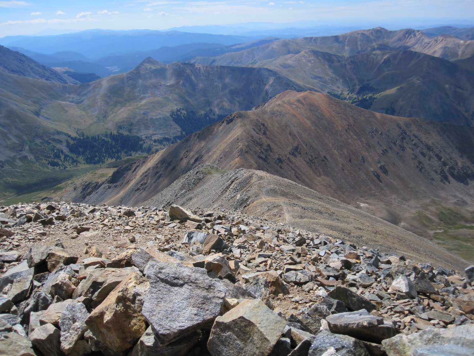
except to the extent that the massive crowds require you to wait, or rush around them. Grays would be an ideal first fourteener. There is very little or no exposure. Nothing really to install a fear of heights or the feeling that a fall would cause serious injury, other than perhaps from the very summit, in places. Looking east from the summit of Grays.
Looking down, from the summit, at the valley we hiked up to get to Grays. The trailhead is on the other side of the mountain to the left.
A group on the summit.
Sam and Andrew on the summit. Torreys in the background.
On the summit we encountered a group of teenagers celebrating a classmate going back to Sweden after living three years in Colorado. They were cooking and eating fondue on the summit.
I couldn't resist a picture, it looked so fun. Sam told me they also had beer and were quite drunk, which I did not notice. I was feeling some altitude issues at the summit. We had climbed Democrat, Cameron and Lincoln the day before, and it caught up with me a little bit. I did not have a headache, and was not really feeling nauseous, although I was not hungry, but I had no energy. Shortly before reaching the summit, I had a short period where I felt like a ton of bricks, just all dead weight with no pick-up. However, I must have had some acclimitization help from my previous hikes because I had much less fluid in my longs than I'd had two weeks before, climbing Mount Nebo, which was over 2,000 feet lower. On our way out, we had some hail and rain, for about the last hour. Andrew also discovered that Colorado is great for mushrooms and in a short period of time was quite excited about the varieties he was able to find.

Saturday, September 4, 2010

Mount Lincoln

Mount Lincoln, at 14,286 feet,
is the 8th tallest peak in Colorado and the tallest peak we climbed on our recent Colorado trip.
It was also unusual because we couldn't see it for much of our hiking day because it was shielded by the just smaller Mount Cameron, which is 14,238 feet and just a half mile away. It has a spikey summit and nice cliffs to the east that provide some beautiful views from the top.
To the north we could see Quandary Peak, another fourteener, and, of course, Cameron and Mount Democrat were to the south.
From the summit of Mount Cameron
it was an easy walk down and then along a nice ridge
to the summit nob. The summit nob was not large, but probably about 50 or 60 feet of rock and shale to the top.
There we found a group of about five people that had made Mount Lincoln (across Mount Cameron) their only destination of the day. This was my favorite part of the hike of this three summit day. Below, Andrew and Sam on the summit.

Friday, September 3, 2010

Mount Cameron

Mount Cameron (as seen from the valley east of Kite Lake),
at 14,238 feet in elevation, is taller than nearby Mount Democrat (14,148 feet),
1.25 miles away. The picture above was taken from Mount Lincoln. Cameron is the rounded peak in the center and Democrat is the pointed peak just to its right. Mount Cameron is also taller than Mount Bross (14,172 feet), 1.01 miles away, but despite being taller than two nearby fourteeners is not considered one of the 53 fourteeners in Colorado. Why? Because nearby Mount Lincoln (14,286 feet), .5 miles away, is a little taller and in the convention used to determine a separate fourteener, usually requiring 300 feet in elevation difference between mountains, including dips into the saddle, it doesn't qualify. Below, see Andrew and Sam on the summit of Cameron and Mount Lincoln, the pointed peak, in the background.
In terms of sex appeal, it has little. It is quite ugly as far as mountains go. It has a rounded, bald nob, and sits between two much sexier mountains, Mount Democrat and Mount Lincoln, both having more pointed peaks and cliffs that make them more ominous and dangerous looking.
I previously posted our hike up Mount Democrat. From the Democrat/Cameron saddle, where Sam is below,
we hiked up the ridge
in a pretty straightforward climb
to the summit. The ridge of Cameron is seen below from Mount Democrat.
We may have actually missed the exact summit. The summit area was quite large and quite flat and we didn't look for a summit marker. We were focused on the much more impresseive Mount Lincoln. Below, also seen from Mount Democrat, is Mount Cameron in the center and the peak of Mount Lincoln a little behind it to the left.
If we did miss the summit of Cameron, it was by only an unexciting foot or two. However, Cameron is only ugly by comparison. If it was on its own, away from the other beauties, it would really be a great hike. As indicated in the Mount Democrat post, we did not climb Mount Bross because it was closed by the landowners. We considered it, knew others were doing it, but decided not to. We did, however, take the route along the side of Mount Bross on the way back down, providing a circular route as opposed to retracing our old steps. So, after hiking to the summit of Mount Lincoln, subject of an upcoming post, we took a trail along the side of Mount Cameron,
to the Cameron/Bross saddle, then along the side of Mount Bross
and
and
and looked back for views of Mount Cameron and the Cameron/Bross saddle.
and switchbacked our way down into the valley
again through a scree pile
that had some awful sections.
The views from the side of Mount Bross were some of the nicest of the day, partly because Democrat, on the other side of the valley, was nicer to look at than Bross, which is about as sexy as Cameron. However, where Democrat was a large rockpile, and mostly solid footholds, Bross was a large screepile, and provided some tenuous footholds, particularly through one notoriously thrilling section. This was where the scree was mostly non-existent and the bare ground provided little traction. We went very slowly and carefully. As it was, Andrew landed on his back twice, and I nearly joined him several times. It was reminiscent of the descent from Sneffles last year down another no-fun screepile. As we got back down to where large rocks began and plants were growing, we had fun listening to and looking for pikas which were all over. Then we stopped briefly at a small waterfall,
a nice touch after a mostly waterless day. Although we only covered about 7 miles during the day, it took as 7 hours to do so. We arrived back at the car about 4:20 p.m. after our late 9:20 a.m. start. The three or four peak package provides a very nice day. It offers variety, a mostly one-way trip, multiple and different peaks and differing views. All-in-all, one of the better days I've spent with my boys. Much of the day they let me lead, allowing me to go at my slower pace. They could have smoked me at any time if they'd wanted to, left me in a pile of dust. I mostly listened as they chatted back and forth defining esoteric words, then asking for and providing words with similar meanings. I didn't understand much of what they said, most of it was over my head. But it was fun to listen in, to learn about what they are learning, what they are interested in, to know that they have both been getting great educations.

Wednesday, September 1, 2010

Mount Democrat

Mount Democrat (as seen from Mount Bross),
just outside Alma, Colorado, in the Mosquito Range, has an elevation of 14,148 feet, and is ranked 28th in height of Colorado's 53 fourteeners (as seen from Mount Cameron).
On Friday, August 27, 2010, I climbed it, and several other nearby peaks, with Sam and Andrew. We started from the Kite Lake Trailhead,
at an elevation of 12,000 feet, which is 6 miles up a dirtroad from Alma (the road as seen from Mount Democrat),
which is itself at over 10,600 feet, about the height of Mount San Bernardino back home. The night before, we stayed in a hotel in Frisco. As we'd gotten little sleep the night before, in preparation to leave for Colorado, we slept in until about 7:00 a.m., then got some breakfast at McDonald's and drove to Alma. We didn't start our hike until 9:20 a.m., much later than my preferred starting time. There were about 20 cars in the dirt parking lot and most of the hikers had already started. The setting is quite dramatic. Kite Lake is in a horseshoe shaped valley surrounded by fourteeners. Mount Democrat is on the left,
Mount Cameron is straight ahead,
and hides Mount Lincoln which is right behind it, and Mount Bross is to its right.
None of the summits are visible, except perhaps Cameron. Bross is closed to hiking because it is on private land and the owners are currently refusing access. We started out walking past Kite Lake, which is near the parking lot.
From above, it is obvious that the name of the lake comes from its shape. The trail then makes its way toward the saddle between Mount Democrat and Mount Cameron. On the way up, there is evidence of mining, including wood from demolished buildings and an orange stain following a water course which is an indicator of iron, copper, or some other mineral that was mined there.
We heard the whistling of a marmot and pretty soon were among a profusion of large white rocks, stacked on top of each other. That pretty much sums up Mount Democrat, one big pile of large rocks.
The mountain looks quite different, depending upon where you are viewing it from. Viewed from the Bross ridge, it looks quite steep and menacing.
As you don't really see the summit until you get quite close to it, it just seems like an endless profusion of stacked rocks, sometimes more rounded, sometimes steeper.
Virtually every step you take is on rock.
Sometimes the steps are large and energy sapping, sometimes they are on relatively smooth and small rocks.
Attention is required as it would be very easy to misstep and twist an ankle. At the Democrat/Cameron saddle,
there was a pretty good wind whipping through and I was anxious to keep moving. We got a view into another valley and of some other mountains beyond.
From the saddle, the trail went up more steeply, with smaller switchbacks. There was very little exposure concern, just an endless array of rocks.
We arrived at the summit some time after 11:00 a.m. There was a beautiful view looking out the valley we'd driven up from Alma,
of the jagged ridge on the side opposite the one we hiked up,
of Quandary and Lincoln Peaks and across the valley toward Mount Bross, which was more rounded and less dramatic. Andrew called Judy on his cellphone and we enjoyed an apple and some water. We got to the peak after some other hikers had left
and were joined by another couple soon after we arrived. It was a beautiful day, the weather was nice, but not too warm, and I loved just being in the presence of Andrew and Sam. After spending a little time on the summit, perhaps 20 minutes or so, we headed down the way we came up, to the Democrat/Cameron saddle, then began our hike up to Mount Cameron, the subject of a later post.